Al ‘Aqabah geodata
Al ‘Aqabah (Al Bayda) is a seat of a second-order administrative division; located in Yemen in Asia/Aden (GMT+3) time zone. In our database, there are 51 cities with bigger population. Compared to other cities in Yemen, 67.9% of cities are located further ↑North; 60.4% of cities are located further ←West and 99% of cities have lower elevation than Al ‘Aqabah. Note1


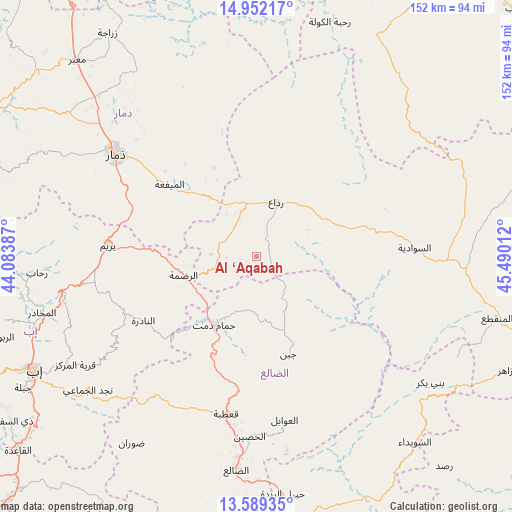
Al ‘Aqabah GPS coordinates[2]
14° 16' 18.444" North, 44° 47' 13.164" East
| Map corner | latitude | longitude |
|---|---|---|
| Upper-left | 14.95217°, | 44.08387° |
| Center: | 14.27179°, | 44.78699° |
| Lower-right: | 13.58935°, | 45.49012° |
| Map W x H: | 151.5×151.5 km | = 94.1×94.1mi |
| max Lat: | 17.76999° ⇑67.9% North |
| Al ‘Aqabah: | 14.27179° |
| min Lat: | ⇓32.1% South 12.18576° |
| min Long | Al ‘Aqabah | max Long |
| 42.67107° | 44.78699° | 54.01895° |
| W 60.4%⇐ | ⇒39.6% E |
Elevation
Elevation of Al ‘Aqabah is 2672 m = 8766 ft, and this is 1367.2 m = 4486 ft above average elevation for this country.
| Max E: |
2791 m = 9157 ft | 1% |
| Al ‘Aqabah | 2672 m 8766 ft | |
| Avg. | 1304.8 m = 4281 ft | |
Min E: |
4 m = 13 ft | 99% |
See also: Yemen elevation on elevation.city.
Geographical zone
Al ‘Aqabah is located in North Torrid zone (between Equator and Tropic of Cancer). Distance of this Northern Tropic circle is 1019 km =633.2 mi to North.| Distance of | km | miles | from Al ‘Aqabah |
|---|---|---|---|
| North Pole | 8420.2 | 5232.1 | to North |
| Arctic Circle | 5814.3 | 3612.8 | to North |
| Tropic Cancer | 1019 | 633.2 | to North |
| Equator | 1586.9 | 986.1 | to South |


Nearby cities:
15 places around Al ‘Aqabah: (largest is in red/bold)
• Al Madu
46.3 km =28.8 mi,  175°
175°
• Al Mayfa’ah
33.4 km =20.8 mi,  309°
309°
• Al Qurayshīyah
27.7 km =17.2 mi,  15°
15°
• An Nādirah
38.8 km =24.1 mi,  239°
239°
• Ar Raḑmah
22.4 km =13.9 mi,  254°
254°
• As Saddah
42.8 km =26.6 mi, 247°
• As Sawādīyah
46.9 km =29.1 mi,  86°
86°
• Ash Sharyah
27.1 km =16.8 mi,  69°
69°
• Juban
30.4 km =18.9 mi,  161°
161°
• Milāḩ
16.1 km =10 mi,  359°
359°
• Qa‘ţabah
47.2 km =29.3 mi,  190°
190°
• Radā‘
16.8 km =10.4 mi, 18°
• Yarīm
44.2 km =27.5 mi,  273°
273°
• Zakhim
11.3 km =7 mi,  283°
283°
• Ḩammām Damt
23.8 km =14.8 mi,  211°
211°
Sources, notices
• [Note1] Compared only with cities in Yemen existing in our database
• [Src1] Map data: © OpenStreetMap contributors (CC-BY-SA)
• [Src2] Other city data from geonames.org with taken over terms of usage.
• [Src3] Geographical zone / Annual Mean Temperature by Robert A. Rohde @ Wikipedia
