Worcester geodata
Worcester (Western Cape) is a seat of a second-order administrative division; located in South Africa in Africa/Johannesburg (GMT+2) time zone. With population of 127,597 people, there are 41 cities with bigger population in this country. Compared to other cities in South Africa, 90.3% of cities are located further ↑North; 91.2% of cities are located further →East and 81.4% of cities have higher elevation than Worcester. Note1
Administrative division(s):
- Level 1: Western Cape
- Level 2: Cape Winelands District Municipality
- Level 3: Breede Valley


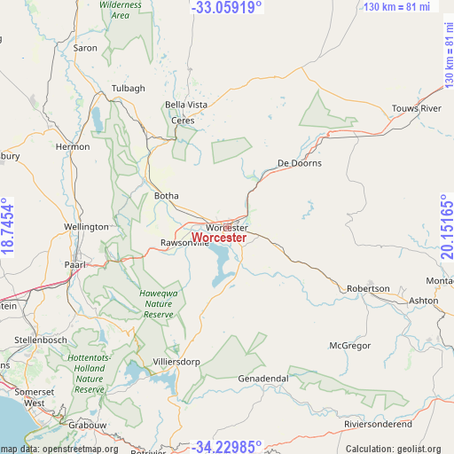
Worcester GPS coordinates[2]
33° 38' 47.436" South, 19° 26' 54.672" East
| Map corner | latitude | longitude |
|---|---|---|
| Upper-left | -33.05919°, | 18.7454° |
| Center: | -33.64651°, | 19.44852° |
| Lower-right: | -34.22985°, | 20.15165° |
| Map W x H: | 130.2×130.2 km | = 80.9×80.9mi |
| max Lat: | -22.34881° ⇑90.3% North |
| Worcester: | -33.64651° |
| min Lat: | ⇓9.7% South -34.66739° |
| min Long | Worcester | max Long |
| 16.8697° | 19.44852° | 32.26762° |
| W 8.8%⇐ | ⇒91.2% E |
Elevation
Elevation of Worcester is 234 m = 768 ft, and this is 735.6 m = 2413 ft below average elevation for this country.
| Max E: |
1873 m = 6145 ft | 81.4% |
| Avg. | 969.6 m = 3181 ft | |
| Worcester | 234 m = 768 ft | |
Min E: |
7 m = 23 ft | 18.6% |
See also: Worcester elevation on elevation.city.
Geographical zone
Worcester is located in South temperate zone (between Tropic of Capricorn and the Antarctic Circle). Distance of this Southern Tropic circle is 1135.2 km =705.4 mi to North.| Distance of | km | miles | from Worcester |
|---|---|---|---|
| Equator | 3741.1 | 2324.6 | to North |
| Tropic Capricorn | 1135.2 | 705.4 | to North |
| Antarctic Circle | 3660 | 2274.2 | to South |
| South Pole | 6265.9 | 3893.4 | to South |


Nearby cities:
15 places around Worcester: (largest is in red/bold)
• Ashton
59.8 km =37.2 mi,  110°
110°
• Atlantis
89.8 km =55.8 mi,  275°
275°
• Caledon
64.9 km =40.3 mi,  181°
181°
• Ceres
33.4 km =20.8 mi,  337°
337°
• Grabouw
68.9 km =42.8 mi,  215°
215°
• Hermanus
88.1 km =54.7 mi,  192°
192°
• Kraaifontein
71.2 km =44.2 mi,  251°
251°
• Malmesbury
70 km =43.5 mi,  287°
287°
• Montagu
64.1 km =39.8 mi,  104°
104°
• Moorreesburg
91.4 km =56.8 mi,  306°
306°
• Paarl
44.8 km =27.8 mi,  257°
257°
• Robertson
44 km =27.3 mi, 113°
• Stellenbosch
62.6 km =38.9 mi,  239°
239°
• Sunset Beach
91.4 km =56.8 mi, 255°
• Wellington
40.5 km =25.2 mi,  271°
271°
Sources, notices
• [Note1] Compared only with cities in South Africa existing in our database
• [Src1] Map data: © OpenStreetMap contributors (CC-BY-SA)
• [Src2] Other city data from geonames.org with taken over terms of usage.
• [Src3] Geographical zone / Annual Mean Temperature by Robert A. Rohde @ Wikipedia
