Arniston geodata
Arniston (Western Cape) is a populated place; located in South Africa in Africa/Johannesburg (GMT+2) time zone. With population of 1,267 people, there are 254 cities with bigger population in this country. Compared to other cities in South Africa, 100% of cities are located further ↑North; 89.4% of cities are located further →East and 97.6% of cities have higher elevation than Arniston. Note1
Administrative division(s):
- Level 1: Western Cape
- Level 2: Overberg District Municipality
- Level 3: Cape Agulhas


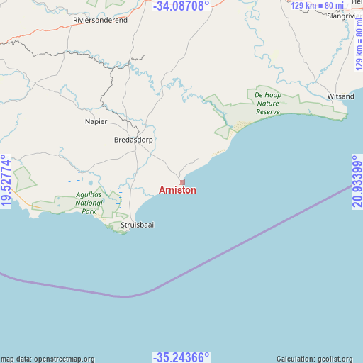
Arniston GPS coordinates[2]
34° 40' 2.604" South, 20° 13' 51.096" East
| Map corner | latitude | longitude |
|---|---|---|
| Upper-left | -34.08708°, | 19.52774° |
| Center: | -34.66739°, | 20.23086° |
| Lower-right: | -35.24366°, | 20.93399° |
| Map W x H: | 128.6×128.6 km | = 79.9×79.9mi |
| max Lat: | -22.34881° ⇑100% North |
| Arniston: | -34.66739° |
| min Lat: | ⇓0% South -34.66739° |
| min Long | Arniston | max Long |
| 16.8697° | 20.23086° | 32.26762° |
| W 10.6%⇐ | ⇒89.4% E |
Elevation
Elevation of Arniston is 19 m = 62 ft, and this is 950.6 m = 3119 ft below average elevation for this country.
| Max E: |
1873 m = 6145 ft | 97.6% |
| Avg. | 969.6 m = 3181 ft | |
| Arniston | 19 m = 62 ft | |
Min E: |
7 m = 23 ft | 2.4% |
See also: South Africa elevation on elevation.city.
Geographical zone
Arniston is located in South temperate zone (between Tropic of Capricorn and the Antarctic Circle). Distance of this Southern Tropic circle is 1248.7 km =775.9 mi to North.| Distance of | km | miles | from Arniston |
|---|---|---|---|
| Equator | 3854.7 | 2395.2 | to North |
| Tropic Capricorn | 1248.7 | 775.9 | to North |
| Antarctic Circle | 3546.5 | 2203.7 | to South |
| South Pole | 6152.4 | 3822.9 | to South |


Nearby cities:
15 places around Arniston: (largest is in red/bold)
• Albertina
134 km =83.3 mi,  67°
67°
• Ashton
94.3 km =58.6 mi,  350°
350°
• Bredasdorp
23 km =14.3 mi,  310°
310°
• Caledon
88.3 km =54.9 mi,  303°
303°
• Grabouw
125.4 km =77.9 mi, 297°
• Hardys Memories of Africa
95.8 km =59.5 mi,  27°
27°
• Hermanus
95.4 km =59.3 mi,  286°
286°
• Montagu
98.4 km =61.1 mi, 354°
• Paarl
155.3 km =96.5 mi, 311°
• Riversdale
113.8 km =70.7 mi,  55°
55°
• Robertson
101.2 km =62.9 mi,  341°
341°
• Stellenbosch
149.5 km =92.9 mi, 303°
• Swellendam
74.3 km =46.2 mi,  15°
15°
• Wellington
160.1 km =99.5 mi,  315°
315°
• Worcester
134.4 km =83.5 mi,  327°
327°
Sources, notices
• [Note1] Compared only with cities in South Africa existing in our database
• [Src1] Map data: © OpenStreetMap contributors (CC-BY-SA)
• [Src2] Other city data from geonames.org with taken over terms of usage.
• [Src3] Geographical zone / Annual Mean Temperature by Robert A. Rohde @ Wikipedia
