Carletonville geodata
Carletonville (Gauteng) is a seat of a third-order administrative division; located in South Africa in Africa/Johannesburg (GMT+2) time zone. With population of 182,304 people, there are 28 cities with bigger population in this country. Compared to other cities in South Africa, 75.2% of cities are located further ↓South; 54.3% of cities are located further →East and 83.2% of cities have lower elevation than Carletonville. Note1
Administrative division(s):
- Level 1: Gauteng
- Level 2: West Rand District Municipality
- Level 3: Merafong City


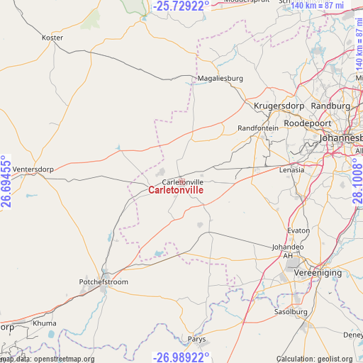
Carletonville GPS coordinates[2]
26° 21' 39.384" South, 27° 23' 51.612" East
| Map corner | latitude | longitude |
|---|---|---|
| Upper-left | -25.72922°, | 26.69455° |
| Center: | -26.36094°, | 27.39767° |
| Lower-right: | -26.98922°, | 28.1008° |
| Map W x H: | 140.1×140.1 km | = 87.1×87.1mi |
| max Lat: | -22.34881° ⇑24.8% North |
| Carletonville: | -26.36094° |
| min Lat: | ⇓75.2% South -34.66739° |
| min Long | Carletonville | max Long |
| 16.8697° | 27.39767° | 32.26762° |
| W 45.7%⇐ | ⇒54.3% E |
Elevation
Elevation of Carletonville is 1529 m = 5016 ft, and this is 559.4 m = 1835 ft above average elevation for this country.
| Max E: |
1873 m = 6145 ft | 16.8% |
| Carletonville | 1529 m 5016 ft | |
| Avg. | 969.6 m = 3181 ft | |
Min E: |
7 m = 23 ft | 83.2% |
See also: Carletonville elevation on elevation.city.
Geographical zone
Carletonville is located in South temperate zone (between Tropic of Capricorn and the Antarctic Circle). Distance of this Southern Tropic circle is 325.1 km =202 mi to North.| Distance of | km | miles | from Carletonville |
|---|---|---|---|
| Equator | 2931.1 | 1821.3 | to North |
| Tropic Capricorn | 325.1 | 202 | to North |
| Antarctic Circle | 4470.1 | 2777.6 | to South |
| South Pole | 7076 | 4396.8 | to South |


Nearby cities:
15 places around Carletonville: (largest is in red/bold)
• Fochville
17.1 km =10.6 mi,  145°
145°
• Krugersdorp
48.5 km =30.1 mi,  50°
50°
• Muldersdriseloop
56.8 km =35.3 mi, 50°
• Orange Farm
48.6 km =30.2 mi,  106°
106°
• Parys
60.6 km =37.7 mi,  174°
174°
• Potchefstroom
49.4 km =30.7 mi,  216°
216°
• Randfontein
36.1 km =22.4 mi,  57°
57°
• Riverlea
59.7 km =37.1 mi,  73°
73°
• Roodepoort
52.2 km =32.4 mi, 65°
• Sasolburg
65.4 km =40.6 mi,  140°
140°
• Soweto
47.1 km =29.3 mi,  77°
77°
• Vanderbijlpark
58.6 km =36.4 mi,  131°
131°
• Ventersdorp
57.6 km =35.8 mi,  275°
275°
• Vereeniging
63 km =39.1 mi,  123°
123°
• Westonaria
25.4 km =15.8 mi, 79°
Sources, notices
• [Note1] Compared only with cities in South Africa existing in our database
• [Src1] Map data: © OpenStreetMap contributors (CC-BY-SA)
• [Src2] Other city data from geonames.org with taken over terms of usage.
• [Src3] Geographical zone / Annual Mean Temperature by Robert A. Rohde @ Wikipedia
