Fochville geodata
Fochville (North-West) is a populated place; located in South Africa in Africa/Johannesburg (GMT+2) time zone. With population of 62,416 people, there are 81 cities with bigger population in this country. Compared to other cities in South Africa, 74% of cities are located further ↓South; 52.2% of cities are located further →East and 79.1% of cities have lower elevation than Fochville. Note1


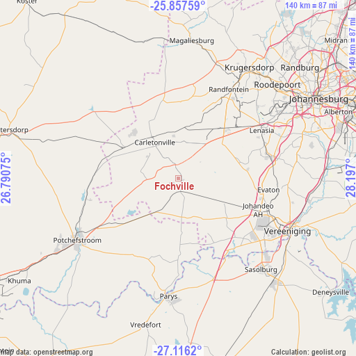
Fochville GPS coordinates[2]
26° 29' 19.032" South, 27° 29' 37.932" East
| Map corner | latitude | longitude |
|---|---|---|
| Upper-left | -25.85759°, | 26.79075° |
| Center: | -26.48862°, | 27.49387° |
| Lower-right: | -27.1162°, | 28.197° |
| Map W x H: | 139.9×139.9 km | = 86.9×86.9mi |
| max Lat: | -22.34881° ⇑26% North |
| Fochville: | -26.48862° |
| min Lat: | ⇓74% South -34.66739° |
| min Long | Fochville | max Long |
| 16.8697° | 27.49387° | 32.26762° |
| W 47.8%⇐ | ⇒52.2% E |
Elevation
Elevation of Fochville is 1478 m = 4849 ft, and this is 508.4 m = 1668 ft above average elevation for this country.
| Max E: |
1873 m = 6145 ft | 20.9% |
| Fochville | 1478 m 4849 ft | |
| Avg. | 969.6 m = 3181 ft | |
Min E: |
7 m = 23 ft | 79.1% |
See also: Fochville elevation on elevation.city.
Geographical zone
Fochville is located in South temperate zone (between Tropic of Capricorn and the Antarctic Circle). Distance of this Southern Tropic circle is 339.3 km =210.8 mi to North.| Distance of | km | miles | from Fochville |
|---|---|---|---|
| Equator | 2945.3 | 1830.1 | to North |
| Tropic Capricorn | 339.3 | 210.8 | to North |
| Antarctic Circle | 4455.9 | 2768.8 | to South |
| South Pole | 7061.8 | 4388 | to South |


Nearby cities:
15 places around Fochville: (largest is in red/bold)
• Carletonville
17.1 km =10.6 mi,  325°
325°
• Krugersdorp
52.8 km =32.8 mi,  32°
32°
• Meyerton
52.9 km =32.9 mi,  98°
98°
• Orange Farm
37.1 km =23.1 mi,  89°
89°
• Parys
46.3 km =28.8 mi,  184°
184°
• Potchefstroom
46.7 km =29 mi,  237°
237°
• Randfontein
39.7 km =24.7 mi, 31°
• Riverlea
56.8 km =35.3 mi,  57°
57°
• Roodepoort
52.3 km =32.5 mi,  46°
46°
• Sasolburg
48.3 km =30 mi,  138°
138°
• Soweto
43.8 km =27.2 mi, 55°
• Vanderbijlpark
42.3 km =26.3 mi,  125°
125°
• Vereeniging
47.6 km =29.6 mi,  115°
115°
• Vredefort
59.2 km =36.8 mi,  192°
192°
• Westonaria
24.4 km =15.2 mi,  39°
39°
Sources, notices
• [Note1] Compared only with cities in South Africa existing in our database
• [Src1] Map data: © OpenStreetMap contributors (CC-BY-SA)
• [Src2] Other city data from geonames.org with taken over terms of usage.
• [Src3] Geographical zone / Annual Mean Temperature by Robert A. Rohde @ Wikipedia
