Ballito geodata
Ballito (KwaZulu-Natal) is a populated place; located in South Africa in Africa/Johannesburg (GMT+2) time zone. With population of 17,218 people, there are 157 cities with bigger population in this country. Compared to other cities in South Africa, 60.8% of cities are located further ↑North; 94.7% of cities are located further ←West and 92.6% of cities have higher elevation than Ballito. Note1
Administrative division(s):
- Level 1: KwaZulu-Natal
- Level 2: iLembe District Municipality
- Level 3: KwaDukuza


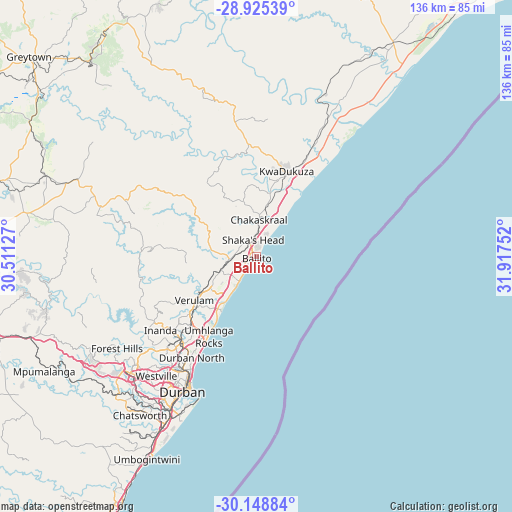
Ballito GPS coordinates[2]
29° 32' 20.292" South, 31° 12' 51.804" East
| Map corner | latitude | longitude |
|---|---|---|
| Upper-left | -28.92539°, | 30.51127° |
| Center: | -29.53897°, | 31.21439° |
| Lower-right: | -30.14884°, | 31.91752° |
| Map W x H: | 136×136 km | = 84.5×84.5mi |
| max Lat: | -22.34881° ⇑60.8% North |
| Ballito: | -29.53897° |
| min Lat: | ⇓39.2% South -34.66739° |
| min Long | Ballito | max Long |
| 16.8697° | 31.21439° | 32.26762° |
| W 94.7%⇐ | ⇒5.3% E |
Elevation
Elevation of Ballito is 51 m = 167 ft, and this is 918.6 m = 3014 ft below average elevation for this country.
| Max E: |
1873 m = 6145 ft | 92.6% |
| Avg. | 969.6 m = 3181 ft | |
| Ballito | 51 m = 167 ft | |
Min E: |
7 m = 23 ft | 7.4% |
See also: South Africa elevation on elevation.city.
Geographical zone
Ballito is located in South temperate zone (between Tropic of Capricorn and the Antarctic Circle). Distance of this Southern Tropic circle is 678.5 km =421.6 mi to North.| Distance of | km | miles | from Ballito |
|---|---|---|---|
| Equator | 3284.4 | 2040.8 | to North |
| Tropic Capricorn | 678.5 | 421.6 | to North |
| Antarctic Circle | 4116.7 | 2558 | to South |
| South Pole | 6722.6 | 4177.2 | to South |


Nearby cities:
15 places around Ballito: (largest is in red/bold)
• Berea
40.8 km =25.4 mi,  211°
211°
• Camperdown
68.3 km =42.4 mi,  252°
252°
• Durban
39.7 km =24.7 mi, 206°
• Eshowe
76.7 km =47.7 mi,  18°
18°
• Greytown
80.1 km =49.8 mi,  311°
311°
• KwaDukuza
24.5 km =15.2 mi, 17°
• Mandeni
47.7 km =29.6 mi, 23°
• Mpumalanga
63.6 km =39.5 mi,  241°
241°
• Ndwedwe
27.9 km =17.3 mi,  275°
275°
• Pietermaritzburg
79.9 km =49.6 mi,  263°
263°
• Scottburgh
94.3 km =58.6 mi, 208°
• Sundumbili
48.4 km =30.1 mi, 21°
• Tongaat Beach
10.2 km =6.3 mi,  215°
215°
• Wartburg
63 km =39.1 mi, 280°
• eMkhomazi
84.4 km =52.4 mi, 208°
Sources, notices
• [Note1] Compared only with cities in South Africa existing in our database
• [Src1] Map data: © OpenStreetMap contributors (CC-BY-SA)
• [Src2] Other city data from geonames.org with taken over terms of usage.
• [Src3] Geographical zone / Annual Mean Temperature by Robert A. Rohde @ Wikipedia
