Berea geodata
Berea (KwaZulu-Natal) is a populated place; located in South Africa in Africa/Johannesburg (GMT+2) time zone. With population of 15,000 people, there are 168 cities with bigger population in this country. Compared to other cities in South Africa, 64.6% of cities are located further ↑North; 92.3% of cities are located further ←West and 89.4% of cities have higher elevation than Berea. Note1
Administrative division(s):
- Level 1: KwaZulu-Natal
- Level 2: eThekwini Metropolitan Municipality
- Level 3: Ethekwini


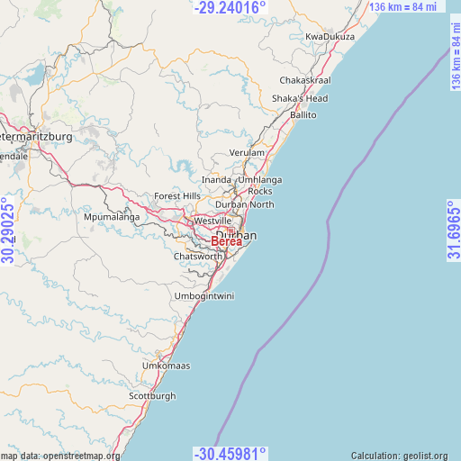
Berea GPS coordinates[2]
29° 51' 6.66" South, 30° 59' 36.132" East
| Map corner | latitude | longitude |
|---|---|---|
| Upper-left | -29.24016°, | 30.29025° |
| Center: | -29.85185°, | 30.99337° |
| Lower-right: | -30.45981°, | 31.6965° |
| Map W x H: | 135.6×135.6 km | = 84.3×84.3mi |
| max Lat: | -22.34881° ⇑64.6% North |
| Berea: | -29.85185° |
| min Lat: | ⇓35.4% South -34.66739° |
| min Long | Berea | max Long |
| 16.8697° | 30.99337° | 32.26762° |
| W 92.3%⇐ | ⇒7.7% E |
Elevation
Elevation of Berea is 92 m = 302 ft, and this is 877.6 m = 2879 ft below average elevation for this country.
| Max E: |
1873 m = 6145 ft | 89.4% |
| Avg. | 969.6 m = 3181 ft | |
| Berea | 92 m = 302 ft | |
Min E: |
7 m = 23 ft | 10.6% |
See also: South Africa elevation on elevation.city.
Geographical zone
Berea is located in South temperate zone (between Tropic of Capricorn and the Antarctic Circle). Distance of this Southern Tropic circle is 713.3 km =443.2 mi to North.| Distance of | km | miles | from Berea |
|---|---|---|---|
| Equator | 3319.2 | 2062.5 | to North |
| Tropic Capricorn | 713.3 | 443.2 | to North |
| Antarctic Circle | 4082 | 2536.4 | to South |
| South Pole | 6687.8 | 4155.6 | to South |


Nearby cities:
15 places around Berea: (largest is in red/bold)
• Ballito
40.8 km =25.4 mi,  31°
31°
• Camperdown
45.6 km =28.3 mi,  287°
287°
• Durban
3.5 km =2.2 mi,  101°
101°
• Howick
84.6 km =52.6 mi,  299°
299°
• KwaDukuza
64.9 km =40.3 mi, 26°
• Mandeni
88.3 km =54.9 mi, 27°
• Mpophomeni
84.1 km =52.3 mi, 292°
• Mpumalanga
34.7 km =21.6 mi,  277°
277°
• Ndwedwe
37.8 km =23.5 mi,  350°
350°
• Pietermaritzburg
63.6 km =39.5 mi, 294°
• Richmond
69.6 km =43.2 mi,  268°
268°
• Scottburgh
53.6 km =33.3 mi,  205°
205°
• Tongaat Beach
30.6 km =19 mi, 30°
• Wartburg
61.7 km =38.3 mi,  319°
319°
• eMkhomazi
43.7 km =27.2 mi, 205°
Sources, notices
• [Note1] Compared only with cities in South Africa existing in our database
• [Src1] Map data: © OpenStreetMap contributors (CC-BY-SA)
• [Src2] Other city data from geonames.org with taken over terms of usage.
• [Src3] Geographical zone / Annual Mean Temperature by Robert A. Rohde @ Wikipedia
