Deneysville geodata
Deneysville (Orange Free State) is a populated place; located in South Africa in Africa/Johannesburg (GMT+2) time zone. With population of 12,397 people, there are 189 cities with bigger population in this country. Compared to other cities in South Africa, 69.6% of cities are located further ↓South; 56.9% of cities are located further ←West and 81.4% of cities have lower elevation than Deneysville. Note1
Administrative division(s):
- Level 1: Orange Free State
- Level 2: Fezile Dabi District Municipality
- Level 3: Metsimaholo


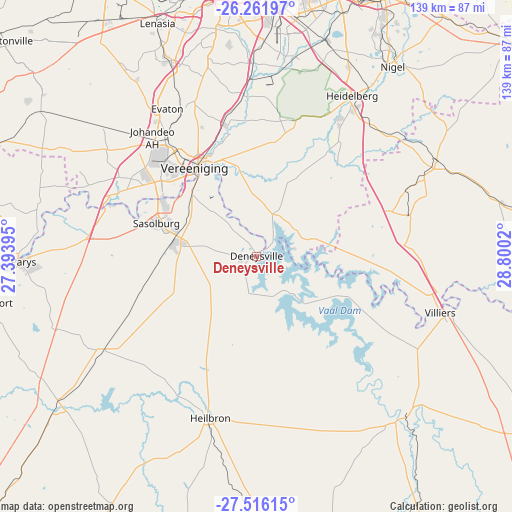
Deneysville GPS coordinates[2]
26° 53' 26.88" South, 28° 5' 49.452" East
| Map corner | latitude | longitude |
|---|---|---|
| Upper-left | -26.26197°, | 27.39395° |
| Center: | -26.8908°, | 28.09707° |
| Lower-right: | -27.51615°, | 28.8002° |
| Map W x H: | 139.5×139.5 km | = 86.7×86.7mi |
| max Lat: | -22.34881° ⇑30.4% North |
| Deneysville: | -26.8908° |
| min Lat: | ⇓69.6% South -34.66739° |
| min Long | Deneysville | max Long |
| 16.8697° | 28.09707° | 32.26762° |
| W 56.9%⇐ | ⇒43.1% E |
Elevation
Elevation of Deneysville is 1513 m = 4964 ft, and this is 543.4 m = 1783 ft above average elevation for this country.
| Max E: |
1873 m = 6145 ft | 18.6% |
| Deneysville | 1513 m 4964 ft | |
| Avg. | 969.6 m = 3181 ft | |
Min E: |
7 m = 23 ft | 81.4% |
See also: South Africa elevation on elevation.city.
Geographical zone
Deneysville is located in South temperate zone (between Tropic of Capricorn and the Antarctic Circle). Distance of this Southern Tropic circle is 384.1 km =238.7 mi to North.| Distance of | km | miles | from Deneysville |
|---|---|---|---|
| Equator | 2990 | 1857.9 | to North |
| Tropic Capricorn | 384.1 | 238.7 | to North |
| Antarctic Circle | 4411.2 | 2741 | to South |
| South Pole | 7017.1 | 4360.2 | to South |


Nearby cities:
15 places around Deneysville: (largest is in red/bold)
• Alberton
69.3 km =43.1 mi,  2°
2°
• Balfour
55.1 km =34.2 mi,  62°
62°
• Frankfort
58.6 km =36.4 mi,  137°
137°
• Heidelberg
50.2 km =31.2 mi,  31°
31°
• Heilbron
45.2 km =28.1 mi,  196°
196°
• Koppies
64.8 km =40.3 mi,  232°
232°
• Meyerton
37.6 km =23.4 mi,  348°
348°
• Nigel
63.5 km =39.5 mi,  36°
36°
• Orange Farm
50.8 km =31.6 mi,  333°
333°
• Parys
63.5 km =39.5 mi,  268°
268°
• Sasolburg
29.1 km =18.1 mi,  287°
287°
• Soweto
73.2 km =45.5 mi,  341°
341°
• Vanderbijlpark
32.5 km =20.2 mi,  307°
307°
• Vereeniging
29.6 km =18.4 mi,  324°
324°
• Villiers
52.3 km =32.5 mi,  107°
107°
Sources, notices
• [Note1] Compared only with cities in South Africa existing in our database
• [Src1] Map data: © OpenStreetMap contributors (CC-BY-SA)
• [Src2] Other city data from geonames.org with taken over terms of usage.
• [Src3] Geographical zone / Annual Mean Temperature by Robert A. Rohde @ Wikipedia
