Vanderbijlpark geodata
Vanderbijlpark (Gauteng) is a seat of a third-order administrative division; located in South Africa in Africa/Johannesburg (GMT+2) time zone. With population of 246,754 people, there are 22 cities with bigger population in this country. Compared to other cities in South Africa, 71.1% of cities are located further ↓South; 51.6% of cities are located further ←West and 79.6% of cities have lower elevation than Vanderbijlpark. Note1
Administrative division(s):
- Level 1: Gauteng
- Level 2: Sedibeng District Municipality
- Level 3: Emfuleni


Vanderbijlpark GPS coordinates[2]
26° 42' 42.156" South, 27° 50' 16.62" East
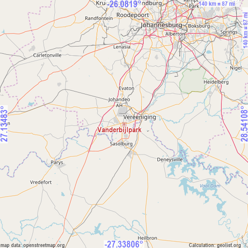
| Map corner | latitude | longitude |
|---|---|---|
| Upper-left | -26.0819°, | 27.13483° |
| Center: | -26.71171°, | 27.83795° |
| Lower-right: | -27.33806°, | 28.54108° |
| Map W x H: | 139.7×139.7 km | = 86.8×86.8mi |
| max Lat: | -22.34881° ⇑28.9% North |
| Vanderbijlpark: | -26.71171° |
| min Lat: | ⇓71.1% South -34.66739° |
| min Long | Vanderbijlpark | max Long |
| 16.8697° | 27.83795° | 32.26762° |
| W 51.6%⇐ | ⇒48.4% E |
Elevation
Elevation of Vanderbijlpark is 1485 m = 4872 ft, and this is 515.4 m = 1691 ft above average elevation for this country.
| Max E: |
1873 m = 6145 ft | 20.4% |
| Vanderbijlpark | 1485 m 4872 ft | |
| Avg. | 969.6 m = 3181 ft | |
Min E: |
7 m = 23 ft | 79.6% |
See also: Vanderbijlpark elevation on elevation.city.
Geographical zone
Vanderbijlpark is located in South temperate zone (between Tropic of Capricorn and the Antarctic Circle). Distance of this Southern Tropic circle is 364.1 km =226.2 mi to North.| Distance of | km | miles | from Vanderbijlpark |
|---|---|---|---|
| Equator | 2970.1 | 1845.5 | to North |
| Tropic Capricorn | 364.1 | 226.2 | to North |
| Antarctic Circle | 4431.1 | 2753.4 | to South |
| South Pole | 7037 | 4372.6 | to South |


Nearby cities:
15 places around Vanderbijlpark: (largest is in red/bold)
• Alberton
56.9 km =35.4 mi,  29°
29°
• Carletonville
58.6 km =36.4 mi,  311°
311°
• Deneysville
32.5 km =20.2 mi,  127°
127°
• Fochville
42.3 km =26.3 mi, 305°
• Heidelberg
56.7 km =35.2 mi,  66°
66°
• Johannesburg
60.2 km =37.4 mi,  19°
19°
• Meyerton
24.7 km =15.3 mi,  46°
46°
• Orange Farm
25.6 km =15.9 mi,  6°
6°
• Parys
43.4 km =27 mi,  240°
240°
• Riverlea
57.2 km =35.5 mi, 13°
• Sasolburg
11.5 km =7.1 mi,  190°
190°
• Soweto
49.4 km =30.7 mi,  2°
2°
• Vereeniging
9.8 km =6.1 mi,  63°
63°
• Vredefort
57.4 km =35.7 mi,  234°
234°
• Westonaria
47.6 km =29.6 mi,  336°
336°
Sources, notices
• [Note1] Compared only with cities in South Africa existing in our database
• [Src1] Map data: © OpenStreetMap contributors (CC-BY-SA)
• [Src2] Other city data from geonames.org with taken over terms of usage.
• [Src3] Geographical zone / Annual Mean Temperature by Robert A. Rohde @ Wikipedia
