Vereeniging geodata
Vereeniging (Gauteng) is a seat of a second-order administrative division; located in South Africa in Africa/Johannesburg (GMT+2) time zone. With population of 474,681 people, there are 10 cities with bigger population in this country. Compared to other cities in South Africa, 71.7% of cities are located further ↓South; 54.6% of cities are located further ←West and 77% of cities have lower elevation than Vereeniging. Note1
Administrative division(s):
- Level 1: Gauteng
- Level 2: Sedibeng District Municipality
- Level 3: Emfuleni


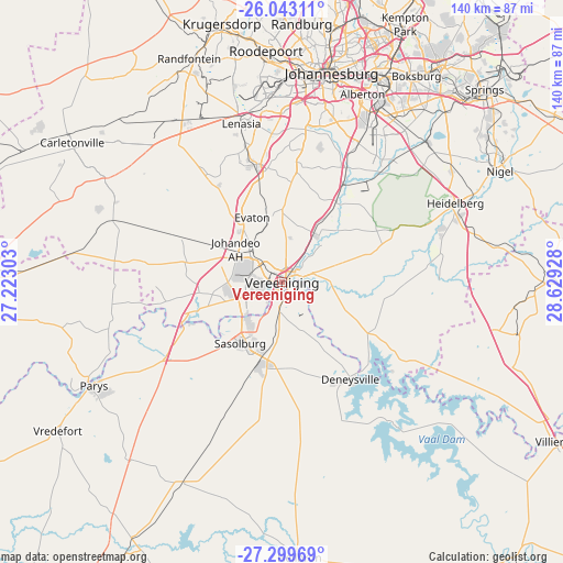
Vereeniging GPS coordinates[2]
26° 40' 23.268" South, 27° 55' 34.14" East
| Map corner | latitude | longitude |
|---|---|---|
| Upper-left | -26.04311°, | 27.22303° |
| Center: | -26.67313°, | 27.92615° |
| Lower-right: | -27.29969°, | 28.62928° |
| Map W x H: | 139.7×139.7 km | = 86.8×86.8mi |
| max Lat: | -22.34881° ⇑28.3% North |
| Vereeniging: | -26.67313° |
| min Lat: | ⇓71.7% South -34.66739° |
| min Long | Vereeniging | max Long |
| 16.8697° | 27.92615° | 32.26762° |
| W 54.6%⇐ | ⇒45.4% E |
Elevation
Elevation of Vereeniging is 1445 m = 4741 ft, and this is 475.4 m = 1560 ft above average elevation for this country.
| Max E: |
1873 m = 6145 ft | 23% |
| Vereeniging | 1445 m 4741 ft | |
| Avg. | 969.6 m = 3181 ft | |
Min E: |
7 m = 23 ft | 77% |
See also: Vereeniging elevation on elevation.city.
Geographical zone
Vereeniging is located in South temperate zone (between Tropic of Capricorn and the Antarctic Circle). Distance of this Southern Tropic circle is 359.9 km =223.6 mi to North.| Distance of | km | miles | from Vereeniging |
|---|---|---|---|
| Equator | 2965.8 | 1842.9 | to North |
| Tropic Capricorn | 359.9 | 223.6 | to North |
| Antarctic Circle | 4435.4 | 2756 | to South |
| South Pole | 7041.3 | 4375.3 | to South |


Nearby cities:
15 places around Vereeniging: (largest is in red/bold)
• Alberton
49.1 km =30.5 mi,  23°
23°
• Deneysville
29.6 km =18.4 mi,  144°
144°
• Fochville
47.6 km =29.6 mi,  295°
295°
• Germiston
54.7 km =34 mi,  27°
27°
• Heidelberg
47 km =29.2 mi,  66°
66°
• Johannesburg
53.6 km =33.3 mi,  12°
12°
• Meyerton
15.6 km =9.7 mi,  36°
36°
• Orange Farm
21.9 km =13.6 mi,  344°
344°
• Parys
53.1 km =33 mi,  241°
241°
• Riverlea
51.5 km =32 mi, 5°
• Roodepoort
57 km =35.4 mi,  354°
354°
• Sasolburg
19 km =11.8 mi,  214°
214°
• Soweto
45.6 km =28.3 mi, 351°
• Vanderbijlpark
9.8 km =6.1 mi, 243°
• Westonaria
48.1 km =29.9 mi,  324°
324°
Sources, notices
• [Note1] Compared only with cities in South Africa existing in our database
• [Src1] Map data: © OpenStreetMap contributors (CC-BY-SA)
• [Src2] Other city data from geonames.org with taken over terms of usage.
• [Src3] Geographical zone / Annual Mean Temperature by Robert A. Rohde @ Wikipedia
