Colesberg geodata
Colesberg (Northern Cape) is a seat of a third-order administrative division; located in South Africa in Africa/Johannesburg (GMT+2) time zone. With population of 12,423 people, there are 188 cities with bigger population in this country. Compared to other cities in South Africa, 70.2% of cities are located further ↑North; 73.2% of cities are located further →East and 70.2% of cities have lower elevation than Colesberg. Note1
Administrative division(s):
- Level 1: Northern Cape
- Level 2: Pixley ka Seme District Municipality
- Level 3: Umsobomvu


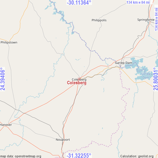
Colesberg GPS coordinates[2]
30° 43' 11.964" South, 25° 5' 49.848" East
| Map corner | latitude | longitude |
|---|---|---|
| Upper-left | -30.11364°, | 24.39406° |
| Center: | -30.71999°, | 25.09718° |
| Lower-right: | -31.32255°, | 25.80031° |
| Map W x H: | 134.4×134.4 km | = 83.5×83.5mi |
| max Lat: | -22.34881° ⇑70.2% North |
| Colesberg: | -30.71999° |
| min Lat: | ⇓29.8% South -34.66739° |
| min Long | Colesberg | max Long |
| 16.8697° | 25.09718° | 32.26762° |
| W 26.8%⇐ | ⇒73.2% E |
Elevation
Elevation of Colesberg is 1369 m = 4491 ft, and this is 399.4 m = 1310 ft above average elevation for this country.
| Max E: |
1873 m = 6145 ft | 29.8% |
| Colesberg | 1369 m 4491 ft | |
| Avg. | 969.6 m = 3181 ft | |
Min E: |
7 m = 23 ft | 70.2% |
See also: South Africa elevation on elevation.city.
Geographical zone
Colesberg is located in South temperate zone (between Tropic of Capricorn and the Antarctic Circle). Distance of this Southern Tropic circle is 809.8 km =503.2 mi to North.| Distance of | km | miles | from Colesberg |
|---|---|---|---|
| Equator | 3415.7 | 2122.4 | to North |
| Tropic Capricorn | 809.8 | 503.2 | to North |
| Antarctic Circle | 3985.4 | 2476.4 | to South |
| South Pole | 6591.3 | 4095.6 | to South |


Nearby cities:
15 places around Colesberg: (largest is in red/bold)
• Aliwal North
154.3 km =95.9 mi,  88°
88°
• Burgersdorp
121.5 km =75.5 mi,  104°
104°
• Cradock
168 km =104.4 mi,  162°
162°
• De Aar
104 km =64.6 mi,  274°
274°
• Graaff-Reinet
178.6 km =111 mi,  197°
197°
• Hopetown
155.9 km =96.9 mi,  321°
321°
• Koffiefontein
146.3 km =90.9 mi,  356°
356°
• Middelburg
86.4 km =53.7 mi,  185°
185°
• Molteno
142.1 km =88.3 mi,  121°
121°
• Noupoort
53.8 km =33.4 mi, 195°
• Orania
120.3 km =74.8 mi,  326°
326°
• Petrusville
82.5 km =51.3 mi, 329°
• Ritchie
193 km =119.9 mi,  345°
345°
• Tarkastad
180.9 km =112.4 mi,  142°
142°
• Trompsburg
100.6 km =62.5 mi,  40°
40°
Sources, notices
• [Note1] Compared only with cities in South Africa existing in our database
• [Src1] Map data: © OpenStreetMap contributors (CC-BY-SA)
• [Src2] Other city data from geonames.org with taken over terms of usage.
• [Src3] Geographical zone / Annual Mean Temperature by Robert A. Rohde @ Wikipedia
