Orania geodata
Orania (Northern Cape) is a populated place; located in South Africa in Africa/Johannesburg (GMT+2) time zone. With population of 1,200 people, there are 255 cities with bigger population in this country. Compared to other cities in South Africa, 64.3% of cities are located further ↑North; 78.2% of cities are located further →East and 50.7% of cities have higher elevation than Orania. Note1
Administrative division(s):
- Level 1: Northern Cape
- Level 2: Pixley ka Seme District Municipality
- Level 3: Thembelihle


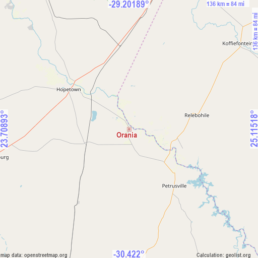
Orania GPS coordinates[2]
29° 48' 49.716" South, 24° 24' 43.38" East
| Map corner | latitude | longitude |
|---|---|---|
| Upper-left | -29.20189°, | 23.70893° |
| Center: | -29.81381°, | 24.41205° |
| Lower-right: | -30.422°, | 25.11518° |
| Map W x H: | 135.7×135.7 km | = 84.3×84.3mi |
| max Lat: | -22.34881° ⇑64.3% North |
| Orania: | -29.81381° |
| min Lat: | ⇓35.7% South -34.66739° |
| min Long | Orania | max Long |
| 16.8697° | 24.41205° | 32.26762° |
| W 21.8%⇐ | ⇒78.2% E |
Elevation
Elevation of Orania is 1111 m = 3645 ft, and this is 141.4 m = 464 ft above average elevation for this country.
| Max E: |
1873 m = 6145 ft | 50.7% |
| Orania | 1111 m 3645 ft | |
| Avg. | 969.6 m = 3181 ft | |
Min E: |
7 m = 23 ft | 49.3% |
See also: South Africa elevation on elevation.city.
Geographical zone
Orania is located in South temperate zone (between Tropic of Capricorn and the Antarctic Circle). Distance of this Southern Tropic circle is 709.1 km =440.6 mi to North.| Distance of | km | miles | from Orania |
|---|---|---|---|
| Equator | 3315 | 2059.8 | to North |
| Tropic Capricorn | 709.1 | 440.6 | to North |
| Antarctic Circle | 4086.2 | 2539 | to South |
| South Pole | 6692.1 | 4158.3 | to South |


Nearby cities:
15 places around Orania: (largest is in red/bold)
• Barkly West
142.5 km =88.5 mi,  4°
4°
• Bloemfontein
190.7 km =118.5 mi,  66°
66°
• Boshof
162.9 km =101.2 mi,  29°
29°
• Colesberg
120.3 km =74.8 mi,  146°
146°
• De Aar
100.6 km =62.5 mi,  202°
202°
• Douglas
104.5 km =64.9 mi,  323°
323°
• Hopetown
37.9 km =23.5 mi,  303°
303°
• Kimberley
125 km =77.7 mi,  15°
15°
• Koffiefontein
72.9 km =45.3 mi,  51°
51°
• Noupoort
161.2 km =100.2 mi,  161°
161°
• Petrusville
38.1 km =23.7 mi,  141°
141°
• Prieska
162 km =100.7 mi,  275°
275°
• Ritchie
88.2 km =54.8 mi,  12°
12°
• Trompsburg
134.1 km =83.3 mi,  100°
100°
• Warrenton
193.7 km =120.4 mi, 12°
Sources, notices
• [Note1] Compared only with cities in South Africa existing in our database
• [Src1] Map data: © OpenStreetMap contributors (CC-BY-SA)
• [Src2] Other city data from geonames.org with taken over terms of usage.
• [Src3] Geographical zone / Annual Mean Temperature by Robert A. Rohde @ Wikipedia
