Ritchie geodata
Ritchie (Northern Cape) is a populated place; located in South Africa in Africa/Johannesburg (GMT+2) time zone. With population of 9,960 people, there are 219 cities with bigger population in this country. Compared to other cities in South Africa, 55.5% of cities are located further ↑North; 77.3% of cities are located further →East and 50.1% of cities have higher elevation than Ritchie. Note1
Administrative division(s):
- Level 1: Northern Cape
- Level 2: Frances Baard District Municipality
- Level 3: Sol Plaatjie


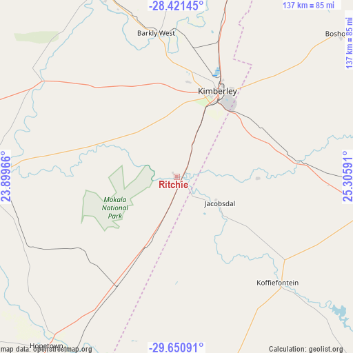
Ritchie GPS coordinates[2]
29° 2' 16.836" South, 24° 36' 10.008" East
| Map corner | latitude | longitude |
|---|---|---|
| Upper-left | -28.42145°, | 23.89966° |
| Center: | -29.03801°, | 24.60278° |
| Lower-right: | -29.65091°, | 25.30591° |
| Map W x H: | 136.7×136.7 km | = 84.9×84.9mi |
| max Lat: | -22.34881° ⇑55.5% North |
| Ritchie: | -29.03801° |
| min Lat: | ⇓44.5% South -34.66739° |
| min Long | Ritchie | max Long |
| 16.8697° | 24.60278° | 32.26762° |
| W 22.7%⇐ | ⇒77.3% E |
Elevation
Elevation of Ritchie is 1115 m = 3658 ft, and this is 145.4 m = 477 ft above average elevation for this country.
| Max E: |
1873 m = 6145 ft | 50.1% |
| Ritchie | 1115 m 3658 ft | |
| Avg. | 969.6 m = 3181 ft | |
Min E: |
7 m = 23 ft | 49.9% |
See also: South Africa elevation on elevation.city.
Geographical zone
Ritchie is located in South temperate zone (between Tropic of Capricorn and the Antarctic Circle). Distance of this Southern Tropic circle is 622.8 km =387 mi to North.| Distance of | km | miles | from Ritchie |
|---|---|---|---|
| Equator | 3228.7 | 2006.2 | to North |
| Tropic Capricorn | 622.8 | 387 | to North |
| Antarctic Circle | 4172.5 | 2592.7 | to South |
| South Pole | 6778.3 | 4211.8 | to South |


Nearby cities:
15 places around Ritchie: (largest is in red/bold)
• Barkly West
56.4 km =35 mi,  351°
351°
• Bloemfontein
156.8 km =97.4 mi,  93°
93°
• Boshof
83.2 km =51.7 mi,  48°
48°
• Christiana
136.4 km =84.8 mi,  23°
23°
• Daniëlskuil
140.3 km =87.2 mi,  312°
312°
• Douglas
80.6 km =50.1 mi,  268°
268°
• Hartswater
144.5 km =89.8 mi,  7°
7°
• Hopetown
82.3 km =51.1 mi,  217°
217°
• Jan Kempdorp
126 km =78.3 mi, 10°
• Kimberley
37.4 km =23.2 mi, 24°
• Koffiefontein
56.5 km =35.1 mi,  136°
136°
• Orania
88.2 km =54.8 mi,  192°
192°
• Pampierstad
139.8 km =86.9 mi,  3°
3°
• Petrusville
116.1 km =72.1 mi,  177°
177°
• Warrenton
105.5 km =65.6 mi, 13°
Sources, notices
• [Note1] Compared only with cities in South Africa existing in our database
• [Src1] Map data: © OpenStreetMap contributors (CC-BY-SA)
• [Src2] Other city data from geonames.org with taken over terms of usage.
• [Src3] Geographical zone / Annual Mean Temperature by Robert A. Rohde @ Wikipedia
