Hopetown geodata
Hopetown (Northern Cape) is a seat of a third-order administrative division; located in South Africa in Africa/Johannesburg (GMT+2) time zone. In our database, there are 257 cities with bigger population. Compared to other cities in South Africa, 62.5% of cities are located further ↑North; 79.1% of cities are located further →East and 51.9% of cities have higher elevation than Hopetown. Note1
Administrative division(s):
- Level 1: Northern Cape
- Level 2: Pixley ka Seme District Municipality
- Level 3: Thembelihle


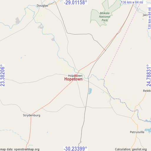
Hopetown GPS coordinates[2]
29° 37' 28.704" South, 24° 5' 6.648" East
| Map corner | latitude | longitude |
|---|---|---|
| Upper-left | -29.01158°, | 23.38206° |
| Center: | -29.62464°, | 24.08518° |
| Lower-right: | -30.23399°, | 24.78831° |
| Map W x H: | 135.9×135.9 km | = 84.4×84.4mi |
| max Lat: | -22.34881° ⇑62.5% North |
| Hopetown: | -29.62464° |
| min Lat: | ⇓37.5% South -34.66739° |
| min Long | Hopetown | max Long |
| 16.8697° | 24.08518° | 32.26762° |
| W 20.9%⇐ | ⇒79.1% E |
Elevation
Elevation of Hopetown is 1095 m = 3593 ft, and this is 125.4 m = 411 ft above average elevation for this country.
| Max E: |
1873 m = 6145 ft | 51.9% |
| Hopetown | 1095 m 3593 ft | |
| Avg. | 969.6 m = 3181 ft | |
Min E: |
7 m = 23 ft | 48.1% |
See also: South Africa elevation on elevation.city.
Geographical zone
Hopetown is located in South temperate zone (between Tropic of Capricorn and the Antarctic Circle). Distance of this Southern Tropic circle is 688 km =427.5 mi to North.| Distance of | km | miles | from Hopetown |
|---|---|---|---|
| Equator | 3294 | 2046.8 | to North |
| Tropic Capricorn | 688 | 427.5 | to North |
| Antarctic Circle | 4107.2 | 2552.1 | to South |
| South Pole | 6713.1 | 4171.3 | to South |


Nearby cities:
15 places around Hopetown: (largest is in red/bold)
• Barkly West
128.3 km =79.7 mi,  19°
19°
• Boshof
164.8 km =102.4 mi,  42°
42°
• Colesberg
155.9 km =96.9 mi,  141°
141°
• Daniëlskuil
168.3 km =104.6 mi,  341°
341°
• De Aar
114.2 km =71 mi,  183°
183°
• Douglas
70.1 km =43.6 mi,  334°
334°
• Kimberley
119 km =73.9 mi,  33°
33°
• Koffiefontein
92.1 km =57.2 mi,  74°
74°
• Orania
37.9 km =23.5 mi,  123°
123°
• Petrusville
75.1 km =46.7 mi,  132°
132°
• Postmasburg
174.5 km =108.4 mi, 325°
• Prieska
129.8 km =80.7 mi,  267°
267°
• Ritchie
82.3 km =51.1 mi, 37°
• Trompsburg
169.7 km =105.4 mi,  105°
105°
• Warrenton
183.6 km =114.1 mi, 23°
Sources, notices
• [Note1] Compared only with cities in South Africa existing in our database
• [Src1] Map data: © OpenStreetMap contributors (CC-BY-SA)
• [Src2] Other city data from geonames.org with taken over terms of usage.
• [Src3] Geographical zone / Annual Mean Temperature by Robert A. Rohde @ Wikipedia
