Parys geodata
Parys (Orange Free State) is a seat of a third-order administrative division; located in South Africa in Africa/Johannesburg (GMT+2) time zone. With population of 71,319 people, there are 72 cities with bigger population in this country. Compared to other cities in South Africa, 69.3% of cities are located further ↓South; 52.8% of cities are located further →East and 72% of cities have lower elevation than Parys. Note1
Administrative division(s):
- Level 1: Orange Free State
- Level 2: Fezile Dabi District Municipality
- Level 3: Ngwathe


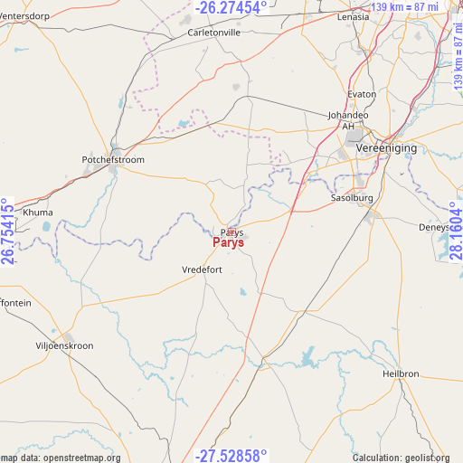
Parys GPS coordinates[2]
26° 54' 11.88" South, 27° 27' 26.172" East
| Map corner | latitude | longitude |
|---|---|---|
| Upper-left | -26.27454°, | 26.75415° |
| Center: | -26.9033°, | 27.45727° |
| Lower-right: | -27.52858°, | 28.1604° |
| Map W x H: | 139.4×139.4 km | = 86.6×86.6mi |
| max Lat: | -22.34881° ⇑30.7% North |
| Parys: | -26.9033° |
| min Lat: | ⇓69.3% South -34.66739° |
| min Long | Parys | max Long |
| 16.8697° | 27.45727° | 32.26762° |
| W 47.2%⇐ | ⇒52.8% E |
Elevation
Elevation of Parys is 1398 m = 4587 ft, and this is 428.4 m = 1406 ft above average elevation for this country.
| Max E: |
1873 m = 6145 ft | 28% |
| Parys | 1398 m 4587 ft | |
| Avg. | 969.6 m = 3181 ft | |
Min E: |
7 m = 23 ft | 72% |
See also: Parys elevation on elevation.city.
Geographical zone
Parys is located in South temperate zone (between Tropic of Capricorn and the Antarctic Circle). Distance of this Southern Tropic circle is 385.4 km =239.5 mi to North.| Distance of | km | miles | from Parys |
|---|---|---|---|
| Equator | 2991.4 | 1858.8 | to North |
| Tropic Capricorn | 385.4 | 239.5 | to North |
| Antarctic Circle | 4409.8 | 2740.1 | to South |
| South Pole | 7015.7 | 4359.4 | to South |


Nearby cities:
15 places around Parys: (largest is in red/bold)
• Carletonville
60.6 km =37.7 mi,  354°
354°
• Deneysville
63.5 km =39.5 mi,  88°
88°
• Fochville
46.3 km =28.8 mi,  4°
4°
• Heilbron
66 km =41 mi,  129°
129°
• Koppies
39.4 km =24.5 mi,  162°
162°
• Meyerton
67.6 km =42 mi,  55°
55°
• Orange Farm
61.9 km =38.5 mi,  41°
41°
• Potchefstroom
41.1 km =25.5 mi,  300°
300°
• Sasolburg
37 km =23 mi,  74°
74°
• Stilfontein
68.6 km =42.6 mi,  275°
275°
• Vanderbijlpark
43.4 km =27 mi, 60°
• Vereeniging
53.1 km =33 mi, 61°
• Viljoenskroon
60.7 km =37.7 mi,  236°
236°
• Vredefort
14.8 km =9.2 mi,  218°
218°
• Westonaria
67.7 km =42.1 mi,  16°
16°
Sources, notices
• [Note1] Compared only with cities in South Africa existing in our database
• [Src1] Map data: © OpenStreetMap contributors (CC-BY-SA)
• [Src2] Other city data from geonames.org with taken over terms of usage.
• [Src3] Geographical zone / Annual Mean Temperature by Robert A. Rohde @ Wikipedia
