Mandeni geodata
Mandeni (KwaZulu-Natal) is a seat of a third-order administrative division; located in South Africa in Africa/Johannesburg (GMT+2) time zone. In our database, there are 257 cities with bigger population. Compared to other cities in South Africa, 57.2% of cities are located further ↑North; 95.9% of cities are located further ←West and 90% of cities have higher elevation than Mandeni. Note1
Administrative division(s):
- Level 1: KwaZulu-Natal
- Level 2: iLembe District Municipality
- Level 3: Mandeni


Mandeni GPS coordinates[2]
29° 8' 48.876" South, 31° 24' 50.508" East
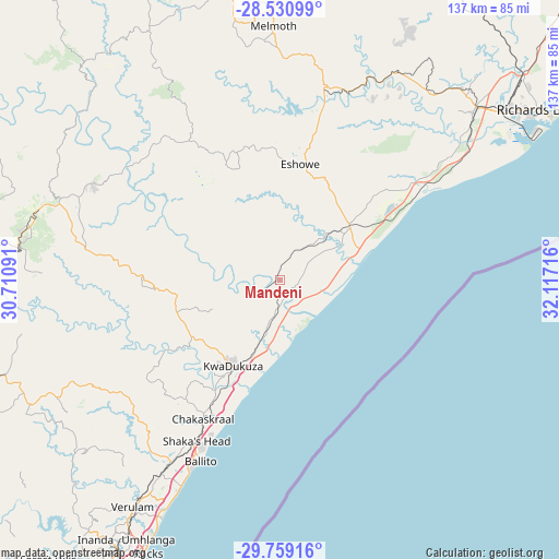
| Map corner | latitude | longitude |
|---|---|---|
| Upper-left | -28.53099°, | 30.71091° |
| Center: | -29.14691°, | 31.41403° |
| Lower-right: | -29.75916°, | 32.11716° |
| Map W x H: | 136.6×136.6 km | = 84.9×84.9mi |
| max Lat: | -22.34881° ⇑57.2% North |
| Mandeni: | -29.14691° |
| min Lat: | ⇓42.8% South -34.66739° |
| min Long | Mandeni | max Long |
| 16.8697° | 31.41403° | 32.26762° |
| W 95.9%⇐ | ⇒4.1% E |
Elevation
Elevation of Mandeni is 88 m = 289 ft, and this is 881.6 m = 2892 ft below average elevation for this country.
| Max E: |
1873 m = 6145 ft | 90% |
| Avg. | 969.6 m = 3181 ft | |
| Mandeni | 88 m = 289 ft | |
Min E: |
7 m = 23 ft | 10% |
See also: South Africa elevation on elevation.city.
Geographical zone
Mandeni is located in South temperate zone (between Tropic of Capricorn and the Antarctic Circle). Distance of this Southern Tropic circle is 634.9 km =394.5 mi to North.| Distance of | km | miles | from Mandeni |
|---|---|---|---|
| Equator | 3240.8 | 2013.7 | to North |
| Tropic Capricorn | 634.9 | 394.5 | to North |
| Antarctic Circle | 4160.3 | 2585.1 | to South |
| South Pole | 6766.2 | 4204.3 | to South |


Nearby cities:
15 places around Mandeni: (largest is in red/bold)
• Ballito
47.7 km =29.6 mi,  203°
203°
• Berea
88.3 km =54.9 mi,  207°
207°
• Durban
87.4 km =54.3 mi, 205°
• Empangeni
63.3 km =39.3 mi,  47°
47°
• Eshowe
29.5 km =18.3 mi,  10°
10°
• Greytown
80.3 km =49.9 mi,  276°
276°
• KwaDukuza
23.5 km =14.6 mi, 210°
• Melmoth
62.3 km =38.7 mi,  358°
358°
• Ndwedwe
62.6 km =38.9 mi,  228°
228°
• Nkandla
66.4 km =41.3 mi,  331°
331°
• Richards Bay
72.9 km =45.3 mi,  56°
56°
• Sundumbili
2.2 km =1.4 mi,  312°
312°
• Tongaat Beach
57.8 km =35.9 mi, 205°
• Wartburg
87.3 km =54.2 mi,  248°
248°
• eSikhaleni
56.3 km =35 mi, 56°
Sources, notices
• [Note1] Compared only with cities in South Africa existing in our database
• [Src1] Map data: © OpenStreetMap contributors (CC-BY-SA)
• [Src2] Other city data from geonames.org with taken over terms of usage.
• [Src3] Geographical zone / Annual Mean Temperature by Robert A. Rohde @ Wikipedia
