Knysna geodata
Knysna (Western Cape) is a seat of a third-order administrative division; located in South Africa in Africa/Johannesburg (GMT+2) time zone. With population of 68,659 people, there are 75 cities with bigger population in this country. Compared to other cities in South Africa, 96.8% of cities are located further ↑North; 82% of cities are located further →East and 99.1% of cities have higher elevation than Knysna. Note1
Administrative division(s):
- Level 1: Western Cape
- Level 2: Eden District Municipality
- Level 3: Knysna


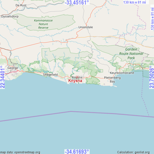
Knysna GPS coordinates[2]
34° 2' 10.572" South, 23° 2' 49.668" East
| Map corner | latitude | longitude |
|---|---|---|
| Upper-left | -33.45161°, | 22.34401° |
| Center: | -34.03627°, | 23.04713° |
| Lower-right: | -34.61693°, | 23.75026° |
| Map W x H: | 129.6×129.6 km | = 80.5×80.5mi |
| max Lat: | -22.34881° ⇑96.8% North |
| Knysna: | -34.03627° |
| min Lat: | ⇓3.2% South -34.66739° |
| min Long | Knysna | max Long |
| 16.8697° | 23.04713° | 32.26762° |
| W 18%⇐ | ⇒82% E |
Elevation
Elevation of Knysna is 9 m = 30 ft, and this is 960.6 m = 3152 ft below average elevation for this country.
| Max E: |
1873 m = 6145 ft | 99.1% |
| Avg. | 969.6 m = 3181 ft | |
| Knysna | 9 m = 30 ft | |
Min E: |
7 m = 23 ft | 0.9% |
See also: Knysna elevation on elevation.city.
Geographical zone
Knysna is located in South temperate zone (between Tropic of Capricorn and the Antarctic Circle). Distance of this Southern Tropic circle is 1178.6 km =732.3 mi to North.| Distance of | km | miles | from Knysna |
|---|---|---|---|
| Equator | 3784.5 | 2351.6 | to North |
| Tropic Capricorn | 1178.6 | 732.3 | to North |
| Antarctic Circle | 3616.7 | 2247.3 | to South |
| South Pole | 6222.6 | 3866.5 | to South |


Nearby cities:
15 places around Knysna: (largest is in red/bold)
• Albertina
136.3 km =84.7 mi,  262°
262°
• Beaufort West
191.7 km =119.1 mi,  346°
346°
• Calitzdorp
138.7 km =86.2 mi,  294°
294°
• De Rust
77 km =47.8 mi,  322°
322°
• George
54.6 km =33.9 mi,  278°
278°
• Kareedouw
115 km =71.5 mi,  85°
85°
• Kruisfontein
155.3 km =96.5 mi, 88°
• Ladismith
175.2 km =108.9 mi, 290°
• Mossel Bay
84.5 km =52.5 mi, 258°
• Oudtshoorn
92.1 km =57.2 mi,  301°
301°
• Plettenberg Bay
30 km =18.6 mi, 93°
• Prince Albert
130.6 km =81.2 mi,  313°
313°
• Riversdale
165 km =102.5 mi,  267°
267°
• Willowmore
92.3 km =57.4 mi,  26°
26°
• Zoar
159.9 km =99.4 mi, 292°
Sources, notices
• [Note1] Compared only with cities in South Africa existing in our database
• [Src1] Map data: © OpenStreetMap contributors (CC-BY-SA)
• [Src2] Other city data from geonames.org with taken over terms of usage.
• [Src3] Geographical zone / Annual Mean Temperature by Robert A. Rohde @ Wikipedia
