Ga-Rankuwa geodata
Ga-Rankuwa (North-West) is a populated place; located in South Africa in Africa/Johannesburg (GMT+2) time zone. With population of 68,767 people, there are 74 cities with bigger population in this country. Compared to other cities in South Africa, 88.8% of cities are located further ↓South; 55.5% of cities are located further ←West and 59% of cities have lower elevation than Ga-Rankuwa. Note1


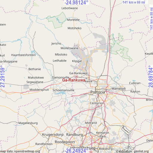
Ga-Rankuwa GPS coordinates[2]
25° 37' 0.912" South, 27° 59' 40.956" East
| Map corner | latitude | longitude |
|---|---|---|
| Upper-left | -24.98124°, | 27.29159° |
| Center: | -25.61692°, | 27.99471° |
| Lower-right: | -26.24924°, | 28.69784° |
| Map W x H: | 141×141 km | = 87.6×87.6mi |
| max Lat: | -22.34881° ⇑11.2% North |
| Ga-Rankuwa: | -25.61692° |
| min Lat: | ⇓88.8% South -34.66739° |
| min Long | Ga-Rankuwa | max Long |
| 16.8697° | 27.99471° | 32.26762° |
| W 55.5%⇐ | ⇒44.5% E |
Elevation
Elevation of Ga-Rankuwa is 1246 m = 4088 ft, and this is 276.4 m = 907 ft above average elevation for this country.
| Max E: |
1873 m = 6145 ft | 41% |
| Ga-Rankuwa | 1246 m 4088 ft | |
| Avg. | 969.6 m = 3181 ft | |
Min E: |
7 m = 23 ft | 59% |
See also: Ga-Rankuwa elevation on elevation.city.
Geographical zone
Ga-Rankuwa is located in South temperate zone (between Tropic of Capricorn and the Antarctic Circle). Distance of this Southern Tropic circle is 242.4 km =150.6 mi to North.| Distance of | km | miles | from Ga-Rankuwa |
|---|---|---|---|
| Equator | 2848.3 | 1769.9 | to North |
| Tropic Capricorn | 242.4 | 150.6 | to North |
| Antarctic Circle | 4552.8 | 2829 | to South |
| South Pole | 7158.7 | 4448.2 | to South |


Nearby cities:
15 places around Ga-Rankuwa: (largest is in red/bold)
• Brits
21.6 km =13.4 mi,  264°
264°
• Centurion
33 km =20.5 mi,  144°
144°
• Cullinan
53.4 km =33.2 mi,  96°
96°
• Diepsloot
35.2 km =21.9 mi,  177°
177°
• Eden Glen Ext 60
59.1 km =36.7 mi,  163°
163°
• Krugersdorp
56.6 km =35.2 mi,  202°
202°
• Mabopane
17 km =10.6 mi,  38°
38°
• Makapanstad
43.5 km =27 mi,  17°
17°
• Midrand
43.5 km =27 mi, 162°
• Midstream
39.3 km =24.4 mi,  148°
148°
• Modderfontein
55.2 km =34.3 mi, 161°
• Muldersdriseloop
49.2 km =30.6 mi, 198°
• Pretoria
24 km =14.9 mi,  126°
126°
• Randburg
53.1 km =33 mi, 179°
• Tembisa
48.2 km =30 mi, 151°
Sources, notices
• [Note1] Compared only with cities in South Africa existing in our database
• [Src1] Map data: © OpenStreetMap contributors (CC-BY-SA)
• [Src2] Other city data from geonames.org with taken over terms of usage.
• [Src3] Geographical zone / Annual Mean Temperature by Robert A. Rohde @ Wikipedia
