Cullinan geodata
Cullinan (Gauteng) is a populated place; located in South Africa in Africa/Johannesburg (GMT+2) time zone. With population of 25,490 people, there are 132 cities with bigger population in this country. Compared to other cities in South Africa, 87.9% of cities are located further ↓South; 65.5% of cities are located further ←West and 77.6% of cities have lower elevation than Cullinan. Note1
Administrative division(s):
- Level 1: Gauteng
- Level 2: City of Tshwane Metropolitan Municipality
- Level 3: City of Tshwane


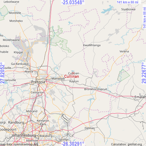
Cullinan GPS coordinates[2]
25° 40' 15.168" South, 28° 31' 25.104" East
| Map corner | latitude | longitude |
|---|---|---|
| Upper-left | -25.03548°, | 27.82052° |
| Center: | -25.67088°, | 28.52364° |
| Lower-right: | -26.30291°, | 29.22677° |
| Map W x H: | 140.9×140.9 km | = 87.6×87.6mi |
| max Lat: | -22.34881° ⇑12.1% North |
| Cullinan: | -25.67088° |
| min Lat: | ⇓87.9% South -34.66739° |
| min Long | Cullinan | max Long |
| 16.8697° | 28.52364° | 32.26762° |
| W 65.5%⇐ | ⇒34.5% E |
Elevation
Elevation of Cullinan is 1449 m = 4754 ft, and this is 479.4 m = 1573 ft above average elevation for this country.
| Max E: |
1873 m = 6145 ft | 22.4% |
| Cullinan | 1449 m 4754 ft | |
| Avg. | 969.6 m = 3181 ft | |
Min E: |
7 m = 23 ft | 77.6% |
See also: South Africa elevation on elevation.city.
Geographical zone
Cullinan is located in South temperate zone (between Tropic of Capricorn and the Antarctic Circle). Distance of this Southern Tropic circle is 248.4 km =154.3 mi to North.| Distance of | km | miles | from Cullinan |
|---|---|---|---|
| Equator | 2854.3 | 1773.6 | to North |
| Tropic Capricorn | 248.4 | 154.3 | to North |
| Antarctic Circle | 4546.8 | 2825.2 | to South |
| South Pole | 7152.7 | 4444.5 | to South |


Nearby cities:
15 places around Cullinan: (largest is in red/bold)
• Benoni
61 km =37.9 mi,  199°
199°
• Bronkhorstspruit
26.8 km =16.7 mi,  125°
125°
• Centurion
39.8 km =24.7 mi,  238°
238°
• Delmas
55.3 km =34.4 mi,  163°
163°
• Diepsloot
58.9 km =36.6 mi, 240°
• Eden Glen Ext 60
62 km =38.5 mi,  215°
215°
• Ekangala
22.8 km =14.2 mi,  97°
97°
• Ga-Rankuwa
53.4 km =33.2 mi,  276°
276°
• Mabopane
46.6 km =29 mi,  294°
294°
• Makapanstad
62 km =38.5 mi,  319°
319°
• Midrand
53.1 km =33 mi,  228°
228°
• Midstream
42.6 km =26.5 mi, 229°
• Modderfontein
58.7 km =36.5 mi, 217°
• Pretoria
34.6 km =21.5 mi,  256°
256°
• Tembisa
46.8 km =29.1 mi, 219°
Sources, notices
• [Note1] Compared only with cities in South Africa existing in our database
• [Src1] Map data: © OpenStreetMap contributors (CC-BY-SA)
• [Src2] Other city data from geonames.org with taken over terms of usage.
• [Src3] Geographical zone / Annual Mean Temperature by Robert A. Rohde @ Wikipedia
