Tagāb geodata
Tagāb (Kapisa) is a populated place; located in Afghanistan in Asia/Kabul (GMT+4.5) time zone. With population of 6,400 people, there are 84 cities with bigger population in this country. Compared to other cities in Afghanistan, 55.6% of cities are located further ↓South; 76.8% of cities are located further ←West and 51.1% of cities have higher elevation than Tagāb. Note1


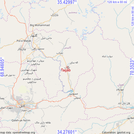
Tagāb GPS coordinates[2]
34° 51' 18.036" North, 69° 38' 57.012" East
| Map corner | latitude | longitude |
|---|---|---|
| Upper-left | 35.42997°, | 68.94605° |
| Center: | 34.85501°, | 69.64917° |
| Lower-right: | 34.27601°, | 70.3523° |
| Map W x H: | 128.3×128.3 km | = 79.7×79.7mi |
| max Lat: | 38.4435° ⇑44.4% North |
| Tagāb: | 34.85501° |
| min Lat: | ⇓55.6% South 30.15° |
| min Long | Tagāb | max Long |
| 61.06667° | 69.64917° | 72.318° |
| W 76.8%⇐ | ⇒23.2% E |
Elevation
Elevation of Tagāb is 1335 m = 4380 ft, and this is 83.4 m = 274 ft below average elevation for this country.
| Max E: |
3068 m = 10066 ft | 51.1% |
| Avg. | 1418.4 m = 4654 ft | |
| Tagāb | 1335 m = 4380 ft | |
Min E: |
254 m = 833 ft | 48.9% |
See also: Afghanistan elevation on elevation.city.
Geographical zone
Tagāb is located in North temperate zone (between Tropic of Cancer and the Arctic Circle). Distance of this Northern Tropic circle is 1269.6 km =788.9 mi to South.| Distance of | km | miles | from Tagāb |
|---|---|---|---|
| North Pole | 6131.5 | 3809.9 | to North |
| Arctic Circle | 3525.7 | 2190.8 | to North |
| Tropic Cancer | 1269.6 | 788.9 | to South |
| Equator | 3875.5 | 2408.1 | to South |


Nearby cities:
15 places around Tagāb: (largest is in red/bold)
• Alah Sāy
8 km =5 mi,  54°
54°
• Charikar
47 km =29.2 mi,  292°
292°
• Dowlat Shāh
39.9 km =24.8 mi,  74°
74°
• Ghulām ‘Alī
39.8 km =24.7 mi, 285°
• Ibrāhīm Khān
42 km =26.1 mi,  301°
301°
• Jabal os Saraj
47.6 km =29.6 mi,  307°
307°
• Kalakān
46.2 km =28.7 mi,  260°
260°
• Pul-e Sangī
45.5 km =28.3 mi,  231°
231°
• Qarah Bāgh Bāzār
43.7 km =27.2 mi,  269°
269°
• Sarōbī
31.2 km =19.4 mi,  161°
161°
• Shērwānī-ye Bālā
18.3 km =11.4 mi,  345°
345°
• Sidqābād
33 km =20.5 mi, 304°
• Ḏanḏar
17.4 km =10.8 mi,  245°
245°
• Ḩājī Khēl
34.4 km =21.4 mi,  325°
325°
• ’Unābah
48.7 km =30.3 mi, 329°
Sources, notices
• [Note1] Compared only with cities in Afghanistan existing in our database
• [Src1] Map data: © OpenStreetMap contributors (CC-BY-SA)
• [Src2] Other city data from geonames.org with taken over terms of usage.
• [Src3] Geographical zone / Annual Mean Temperature by Robert A. Rohde @ Wikipedia
