Sarōbī geodata
Sarōbī (Kabul) is a seat of a second-order administrative division; located in Afghanistan in Asia/Kabul (GMT+4.5) time zone. In our database, there are 93 cities with bigger population. Compared to other cities in Afghanistan, 52.1% of cities are located further ↑North; 78.8% of cities are located further ←West and 66.2% of cities have higher elevation than Sarōbī. Note1


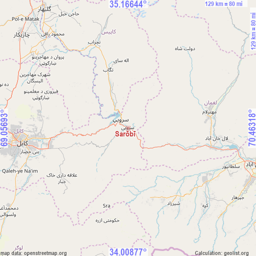
Sarōbī GPS coordinates[2]
34° 35' 22.632" North, 69° 45' 36.18" East
| Map corner | latitude | longitude |
|---|---|---|
| Upper-left | 35.16644°, | 69.05693° |
| Center: | 34.58962°, | 69.76005° |
| Lower-right: | 34.00877°, | 70.46318° |
| Map W x H: | 128.7×128.7 km | = 80×80mi |
| max Lat: | 38.4435° ⇑52.1% North |
| Sarōbī: | 34.58962° |
| min Lat: | ⇓47.9% South 30.15° |
| min Long | Sarōbī | max Long |
| 61.06667° | 69.76005° | 72.318° |
| W 78.8%⇐ | ⇒21.2% E |
Elevation
Elevation of Sarōbī is 987 m = 3238 ft, and this is 431.4 m = 1415 ft below average elevation for this country.
| Max E: |
3068 m = 10066 ft | 66.2% |
| Avg. | 1418.4 m = 4654 ft | |
| Sarōbī | 987 m = 3238 ft | |
Min E: |
254 m = 833 ft | 33.8% |
See also: Afghanistan elevation on elevation.city.
Geographical zone
Sarōbī is located in North temperate zone (between Tropic of Cancer and the Arctic Circle). Distance of this Northern Tropic circle is 1240.1 km =770.6 mi to South.| Distance of | km | miles | from Sarōbī |
|---|---|---|---|
| North Pole | 6161.1 | 3828.3 | to North |
| Arctic Circle | 3555.2 | 2209.1 | to North |
| Tropic Cancer | 1240.1 | 770.6 | to South |
| Equator | 3846 | 2389.8 | to South |


Nearby cities:
15 places around Sarōbī: (largest is in red/bold)
• Alah Sāy
34.3 km =21.3 mi,  353°
353°
• Bagrāmī
45.8 km =28.5 mi,  256°
256°
• Chakaray
40.5 km =25.2 mi,  226°
226°
• Dowlat Shāh
49.2 km =30.6 mi,  35°
35°
• Kabul
54.2 km =33.7 mi, 262°
• Kaz̲h̲ah
54.8 km =34.1 mi,  135°
135°
• Mehtar Lām
42.1 km =26.2 mi,  77°
77°
• Māmā Khēl
44 km =27.3 mi,  150°
150°
• Pul-e Sangī
45.8 km =28.5 mi,  271°
271°
• Qarghah’ī
44.4 km =27.6 mi,  95°
95°
• Shērwānī-ye Bālā
49.5 km =30.8 mi,  342°
342°
• Sulţānpūr-e ‘Ulyā
53 km =32.9 mi,  111°
111°
• Tagāb
31.2 km =19.4 mi, 341°
• Ḏanḏar
34.4 km =21.4 mi,  310°
310°
• Ḩukūmatī Azrah
47.4 km =29.5 mi,  192°
192°
Sources, notices
• [Note1] Compared only with cities in Afghanistan existing in our database
• [Src1] Map data: © OpenStreetMap contributors (CC-BY-SA)
• [Src2] Other city data from geonames.org with taken over terms of usage.
• [Src3] Geographical zone / Annual Mean Temperature by Robert A. Rohde @ Wikipedia
