Alah Sāy geodata
Alah Sāy (Kapisa) is a seat of a second-order administrative division; located in Afghanistan in Asia/Kabul (GMT+4.5) time zone. In our database, there are 93 cities with bigger population. Compared to other cities in Afghanistan, 56.9% of cities are located further ↓South; 77.8% of cities are located further ←West and 59.2% of cities have lower elevation than Alah Sāy. Note1


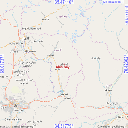
Alah Sāy GPS coordinates[2]
34° 53' 47.4" North, 69° 43' 13.764" East
| Map corner | latitude | longitude |
|---|---|---|
| Upper-left | 35.47116°, | 69.01737° |
| Center: | 34.8965°, | 69.72049° |
| Lower-right: | 34.31779°, | 70.42362° |
| Map W x H: | 128.2×128.2 km | = 79.7×79.7mi |
| max Lat: | 38.4435° ⇑43.1% North |
| Alah Sāy: | 34.8965° |
| min Lat: | ⇓56.9% South 30.15° |
| min Long | Alah Sāy | max Long |
| 61.06667° | 69.72049° | 72.318° |
| W 77.8%⇐ | ⇒22.2% E |
Elevation
Elevation of Alah Sāy is 1602 m = 5256 ft, and this is 183.6 m = 602 ft above average elevation for this country.
| Max E: |
3068 m = 10066 ft | 40.8% |
| Alah Sāy | 1602 m 5256 ft | |
| Avg. | 1418.4 m = 4654 ft | |
Min E: |
254 m = 833 ft | 59.2% |
See also: Afghanistan elevation on elevation.city.
Geographical zone
Alah Sāy is located in North temperate zone (between Tropic of Cancer and the Arctic Circle). Distance of this Northern Tropic circle is 1274.2 km =791.8 mi to South.| Distance of | km | miles | from Alah Sāy |
|---|---|---|---|
| North Pole | 6126.9 | 3807.1 | to North |
| Arctic Circle | 3521 | 2187.8 | to North |
| Tropic Cancer | 1274.2 | 791.8 | to South |
| Equator | 3880.1 | 2411 | to South |


Nearby cities:
15 places around Alah Sāy: (largest is in red/bold)
• Bāzārak
49.9 km =31 mi,  338°
338°
• Dowlat Shāh
32.5 km =20.2 mi,  79°
79°
• Ghulām ‘Alī
45.2 km =28.1 mi,  277°
277°
• Ibrāhīm Khān
45.7 km =28.4 mi,  292°
292°
• Jabal os Saraj
50.4 km =31.3 mi,  299°
299°
• Kirāmān
44.7 km =27.8 mi,  355°
355°
• Mehtar Lām
51.2 km =31.8 mi,  119°
119°
• Qarah Bāgh Bāzār
50.4 km =31.3 mi,  264°
264°
• Sarōbī
34.3 km =21.3 mi,  173°
173°
• Shērwānī-ye Bālā
17.2 km =10.7 mi,  319°
319°
• Sidqābād
36.5 km =22.7 mi, 292°
• Tagāb
8 km =5 mi,  234°
234°
• Ḏanḏar
25.3 km =15.7 mi,  242°
242°
• Ḩājī Khēl
35.3 km =21.9 mi,  312°
312°
• ’Unābah
48.7 km =30.3 mi, 320°
Sources, notices
• [Note1] Compared only with cities in Afghanistan existing in our database
• [Src1] Map data: © OpenStreetMap contributors (CC-BY-SA)
• [Src2] Other city data from geonames.org with taken over terms of usage.
• [Src3] Geographical zone / Annual Mean Temperature by Robert A. Rohde @ Wikipedia
