Ḩukūmatī Azrah geodata
Ḩukūmatī Azrah (Logar) is a seat of a second-order administrative division; located in Afghanistan in Asia/Kabul (GMT+4.5) time zone. With population of 12,526 people, there are 56 cities with bigger population in this country. Compared to other cities in Afghanistan, 63.7% of cities are located further ↑North; 76.5% of cities are located further ←West and 88.7% of cities have lower elevation than Ḩukūmatī Azrah. Note1


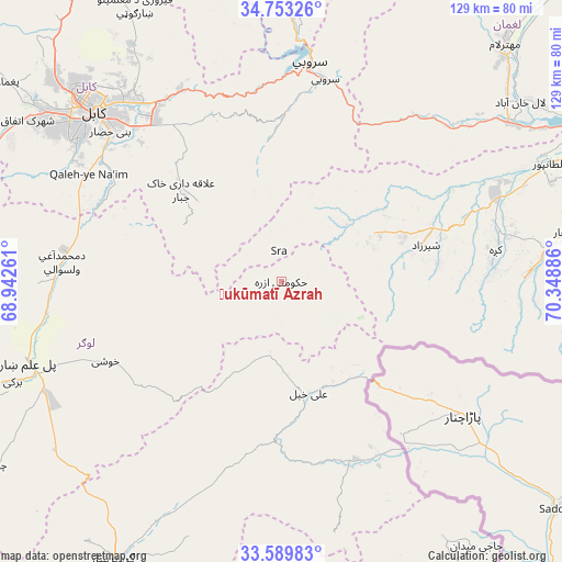
Ḩukūmatī Azrah GPS coordinates[2]
34° 10' 24.78" North, 69° 38' 44.628" East
| Map corner | latitude | longitude |
|---|---|---|
| Upper-left | 34.75326°, | 68.94261° |
| Center: | 34.17355°, | 69.64573° |
| Lower-right: | 33.58983°, | 70.34886° |
| Map W x H: | 129.4×129.4 km | = 80.4×80.4mi |
| max Lat: | 38.4435° ⇑63.7% North |
| Ḩukūmatī Azrah: | 34.17355° |
| min Lat: | ⇓36.3% South 30.15° |
| min Long | Ḩukūmatī Az | max Long |
| 61.06667° | 69.64573° | 72.318° |
| W 76.5%⇐ | ⇒23.5% E |
Elevation
Elevation of Ḩukūmatī Azrah is 2330 m = 7644 ft, and this is 911.6 m = 2991 ft above average elevation for this country.
| Max E: |
3068 m = 10066 ft | 11.3% |
| Ḩukūmatī Azrah | 2330 m 7644 ft | |
| Avg. | 1418.4 m = 4654 ft | |
Min E: |
254 m = 833 ft | 88.7% |
See also: Afghanistan elevation on elevation.city.
Geographical zone
Ḩukūmatī Azrah is located in North temperate zone (between Tropic of Cancer and the Arctic Circle). Distance of this Northern Tropic circle is 1193.8 km =741.8 mi to South.| Distance of | km | miles | from Ḩukūmatī Azrah |
|---|---|---|---|
| North Pole | 6207.3 | 3857 | to North |
| Arctic Circle | 3601.4 | 2237.8 | to North |
| Tropic Cancer | 1193.8 | 741.8 | to South |
| Equator | 3799.7 | 2361 | to South |


Nearby cities:
15 places around Ḩukūmatī Azrah: (largest is in red/bold)
• Bagrāmī
49.3 km =30.6 mi,  316°
316°
• Chakaray
26.7 km =16.6 mi,  314°
314°
• Kabul
58.7 km =36.5 mi, 312°
• Kaz̲h̲ah
49.9 km =31 mi,  81°
81°
• Khōshī
44.1 km =27.4 mi,  243°
243°
• Muḩammad Āghah Wuluswālī
50.4 km =31.3 mi,  275°
275°
• Māmā Khēl
33.2 km =20.6 mi, 76°
• Pachīr wa Āgām
58.2 km =36.2 mi,  87°
87°
• Pul-e Sangī
59.1 km =36.7 mi, 323°
• Qal‘ah-ye Na‘īm
50.6 km =31.4 mi,  299°
299°
• Sarōbī
47.4 km =29.5 mi,  12°
12°
• Tsamkanī
44.1 km =27.4 mi,  159°
159°
• Tsapêraī
45.8 km =28.5 mi,  146°
146°
• Wulêswālī Sayyid Karam
59.5 km =37 mi,  205°
205°
• ‘Alī Khēl
26.6 km =16.5 mi,  165°
165°
Sources, notices
• [Note1] Compared only with cities in Afghanistan existing in our database
• [Src1] Map data: © OpenStreetMap contributors (CC-BY-SA)
• [Src2] Other city data from geonames.org with taken over terms of usage.
• [Src3] Geographical zone / Annual Mean Temperature by Robert A. Rohde @ Wikipedia
