Chakaray geodata
Chakaray (Kabul) is a seat of a second-order administrative division; located in Afghanistan in Asia/Kabul (GMT+4.5) time zone. In our database, there are 93 cities with bigger population. Compared to other cities in Afghanistan, 60.1% of cities are located further ↑North; 72% of cities are located further ←West and 90% of cities have lower elevation than Chakaray. Note1


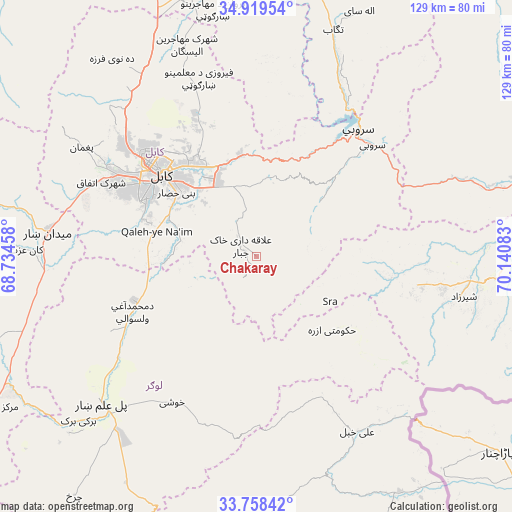
Chakaray GPS coordinates[2]
34° 20' 27.564" North, 69° 26' 15.72" East
| Map corner | latitude | longitude |
|---|---|---|
| Upper-left | 34.91954°, | 68.73458° |
| Center: | 34.34099°, | 69.4377° |
| Lower-right: | 33.75842°, | 70.14083° |
| Map W x H: | 129.1×129.1 km | = 80.2×80.2mi |
| max Lat: | 38.4435° ⇑60.1% North |
| Chakaray: | 34.34099° |
| min Lat: | ⇓39.9% South 30.15° |
| min Long | Chakaray | max Long |
| 61.06667° | 69.4377° | 72.318° |
| W 72%⇐ | ⇒28% E |
Elevation
Elevation of Chakaray is 2372 m = 7782 ft, and this is 953.6 m = 3129 ft above average elevation for this country.
| Max E: |
3068 m = 10066 ft | 10% |
| Chakaray | 2372 m 7782 ft | |
| Avg. | 1418.4 m = 4654 ft | |
Min E: |
254 m = 833 ft | 90% |
See also: Afghanistan elevation on elevation.city.
Geographical zone
Chakaray is located in North temperate zone (between Tropic of Cancer and the Arctic Circle). Distance of this Northern Tropic circle is 1212.4 km =753.4 mi to South.| Distance of | km | miles | from Chakaray |
|---|---|---|---|
| North Pole | 6188.7 | 3845.5 | to North |
| Arctic Circle | 3582.8 | 2226.2 | to North |
| Tropic Cancer | 1212.4 | 753.4 | to South |
| Equator | 3818.4 | 2372.6 | to South |


Nearby cities:
15 places around Chakaray: (largest is in red/bold)
• Bagrāmī
22.7 km =14.1 mi,  318°
318°
• Chandal Bā’ī
51.9 km =32.2 mi,  301°
301°
• Kabul
32 km =19.9 mi,  310°
310°
• Khōshī
43.1 km =26.8 mi,  208°
208°
• Maydanshakhr
52.8 km =32.8 mi,  276°
276°
• Muḩammad Āghah Wuluswālī
34.1 km =21.2 mi,  245°
245°
• Māmā Khēl
52.5 km =32.6 mi,  101°
101°
• Paghmān
52.4 km =32.6 mi, 301°
• Pul-e Sangī
33.1 km =20.6 mi,  330°
330°
• Qal‘ah-ye Na‘īm
25.7 km =16 mi, 284°
• Sarōbī
40.5 km =25.2 mi,  46°
46°
• Surkh Bilandī
53.5 km =33.2 mi, 315°
• Ḏanḏar
50.1 km =31.1 mi,  3°
3°
• Ḩukūmatī Azrah
26.7 km =16.6 mi,  134°
134°
• ‘Alī Khēl
51.3 km =31.9 mi,  149°
149°
Sources, notices
• [Note1] Compared only with cities in Afghanistan existing in our database
• [Src1] Map data: © OpenStreetMap contributors (CC-BY-SA)
• [Src2] Other city data from geonames.org with taken over terms of usage.
• [Src3] Geographical zone / Annual Mean Temperature by Robert A. Rohde @ Wikipedia
