Pachīr wa Āgām geodata
Pachīr wa Āgām (Nangarhar) is a seat of a second-order administrative division; located in Afghanistan in Asia/Kabul (GMT+4.5) time zone. In our database, there are 93 cities with bigger population. Compared to other cities in Afghanistan, 63.3% of cities are located further ↑North; 85.9% of cities are located further ←West and 55.6% of cities have higher elevation than Pachīr wa Āgām. Note1


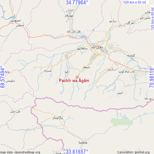
Pachīr wa Āgām GPS coordinates[2]
34° 12' 0.396" North, 70° 16' 41.016" East
| Map corner | latitude | longitude |
|---|---|---|
| Upper-left | 34.77964°, | 69.57494° |
| Center: | 34.20011°, | 70.27806° |
| Lower-right: | 33.61657°, | 70.98119° |
| Map W x H: | 129.3×129.3 km | = 80.3×80.3mi |
| max Lat: | 38.4435° ⇑63.3% North |
| Pachīr wa Āgām: | 34.20011° |
| min Lat: | ⇓36.7% South 30.15° |
| min Long | Pachīr wa Āg� | max Long |
| 61.06667° | 70.27806° | 72.318° |
| W 85.9%⇐ | ⇒14.1% E |
Elevation
Elevation of Pachīr wa Āgām is 1241 m = 4072 ft, and this is 177.4 m = 582 ft below average elevation for this country.
| Max E: |
3068 m = 10066 ft | 55.6% |
| Avg. | 1418.4 m = 4654 ft | |
| Pachīr wa Āgām | 1241 m = 4072 ft | |
Min E: |
254 m = 833 ft | 44.4% |
See also: Afghanistan elevation on elevation.city.
Geographical zone
Pachīr wa Āgām is located in North temperate zone (between Tropic of Cancer and the Arctic Circle). Distance of this Northern Tropic circle is 1196.8 km =743.7 mi to South.| Distance of | km | miles | from Pachīr wa Āgām |
|---|---|---|---|
| North Pole | 6204.4 | 3855.2 | to North |
| Arctic Circle | 3598.5 | 2236 | to North |
| Tropic Cancer | 1196.8 | 743.7 | to South |
| Equator | 3802.7 | 2362.9 | to South |


Nearby cities:
15 places around Pachīr wa Āgām: (largest is in red/bold)
• Bāsawul
54.9 km =34.1 mi,  84°
84°
• Gōshtah
47.9 km =29.8 mi,  68°
68°
• Jalālābād
29.8 km =18.5 mi,  32°
32°
• Kai
41.3 km =25.7 mi,  101°
101°
• Kaz̲h̲ah
9.9 km =6.2 mi,  297°
297°
• Khafizan
13 km =8.1 mi,  42°
42°
• Kōṯowāl
20 km =12.4 mi,  122°
122°
• Markaz-e Woluswalī-ye Āchīn
40.4 km =25.1 mi, 101°
• Mehtar Lām
52.8 km =32.8 mi,  353°
353°
• Māmā Khēl
26.3 km =16.3 mi,  280°
280°
• Qarghah’ī
39.5 km =24.5 mi,  355°
355°
• Sangar Sarāy
40.4 km =25.1 mi,  55°
55°
• Sheywah
50.2 km =31.2 mi, 34°
• Sulţānpūr-e ‘Ulyā
23.6 km =14.7 mi,  4°
4°
• Tsapêraī
52.8 km =32.8 mi,  218°
218°
Sources, notices
• [Note1] Compared only with cities in Afghanistan existing in our database
• [Src1] Map data: © OpenStreetMap contributors (CC-BY-SA)
• [Src2] Other city data from geonames.org with taken over terms of usage.
• [Src3] Geographical zone / Annual Mean Temperature by Robert A. Rohde @ Wikipedia
