Paghmān geodata
Paghmān (Kabul) is a populated place; located in Afghanistan in Asia/Kabul (GMT+4.5) time zone. With population of 49,157 people, there are 22 cities with bigger population in this country. Compared to other cities in Afghanistan, 52.4% of cities are located further ↑North; 58.2% of cities are located further ←West and 88.4% of cities have lower elevation than Paghmān. Note1


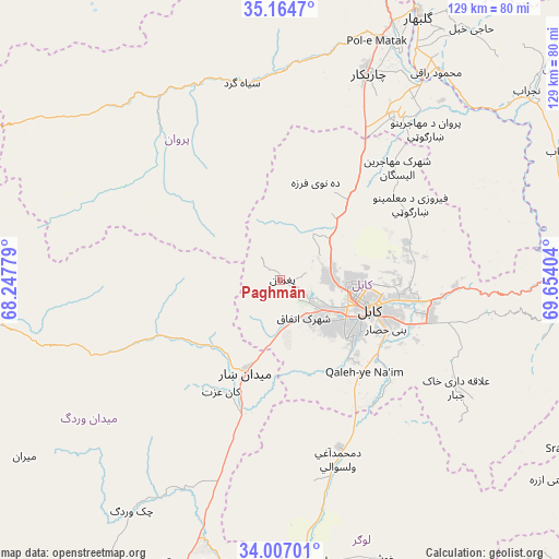
Paghmān GPS coordinates[2]
34° 35' 16.332" North, 68° 57' 3.276" East
| Map corner | latitude | longitude |
|---|---|---|
| Upper-left | 35.1647°, | 68.24779° |
| Center: | 34.58787°, | 68.95091° |
| Lower-right: | 34.00701°, | 69.65404° |
| Map W x H: | 128.7×128.7 km | = 80×80mi |
| max Lat: | 38.4435° ⇑52.4% North |
| Paghmān: | 34.58787° |
| min Lat: | ⇓47.6% South 30.15° |
| min Long | Paghmān | max Long |
| 61.06667° | 68.95091° | 72.318° |
| W 58.2%⇐ | ⇒41.8% E |
Elevation
Elevation of Paghmān is 2328 m = 7638 ft, and this is 909.6 m = 2984 ft above average elevation for this country.
| Max E: |
3068 m = 10066 ft | 11.6% |
| Paghmān | 2328 m 7638 ft | |
| Avg. | 1418.4 m = 4654 ft | |
Min E: |
254 m = 833 ft | 88.4% |
See also: Paghmān elevation on elevation.city.
Geographical zone
Paghmān is located in North temperate zone (between Tropic of Cancer and the Arctic Circle). Distance of this Northern Tropic circle is 1239.9 km =770.4 mi to South.| Distance of | km | miles | from Paghmān |
|---|---|---|---|
| North Pole | 6161.3 | 3828.5 | to North |
| Arctic Circle | 3555.4 | 2209.2 | to North |
| Tropic Cancer | 1239.9 | 770.4 | to South |
| Equator | 3845.8 | 2389.7 | to South |


Nearby cities:
15 places around Paghmān: (largest is in red/bold)
• Bagrāmī
31.4 km =19.5 mi,  109°
109°
• Chandal Bā’ī
0.5 km =0.3 mi,  131°
131°
• Deh-e Now
19.9 km =12.4 mi,  26°
26°
• Istālif
29.6 km =18.4 mi,  23°
23°
• Jalrēz
30.1 km =18.7 mi,  244°
244°
• Kabul
21.3 km =13.2 mi, 108°
• Kalakān
28.4 km =17.6 mi,  39°
39°
• Maydanshakhr
22.7 km =14.1 mi,  199°
199°
• Muḩammad Āghah Wuluswālī
43.7 km =27.2 mi,  161°
161°
• Mīr Bachah Kōṯ
23.7 km =14.7 mi, 40°
• Pul-e Sangī
28.3 km =17.6 mi,  87°
87°
• Qal‘ah-ye Na‘īm
28.8 km =17.9 mi,  136°
136°
• Qarah Bāgh Bāzār
35.7 km =22.2 mi, 34°
• Surkh Bilandī
12.9 km =8 mi, 33°
• Zargarān
24.3 km =15.1 mi, 23°
Sources, notices
• [Note1] Compared only with cities in Afghanistan existing in our database
• [Src1] Map data: © OpenStreetMap contributors (CC-BY-SA)
• [Src2] Other city data from geonames.org with taken over terms of usage.
• [Src3] Geographical zone / Annual Mean Temperature by Robert A. Rohde @ Wikipedia
