Istālif geodata
Istālif (Kabul) is a seat of a second-order administrative division; located in Afghanistan in Asia/Kabul (GMT+4.5) time zone. In our database, there are 93 cities with bigger population. Compared to other cities in Afghanistan, 54.7% of cities are located further ↓South; 60.8% of cities are located further ←West and 69.5% of cities have lower elevation than Istālif. Note1


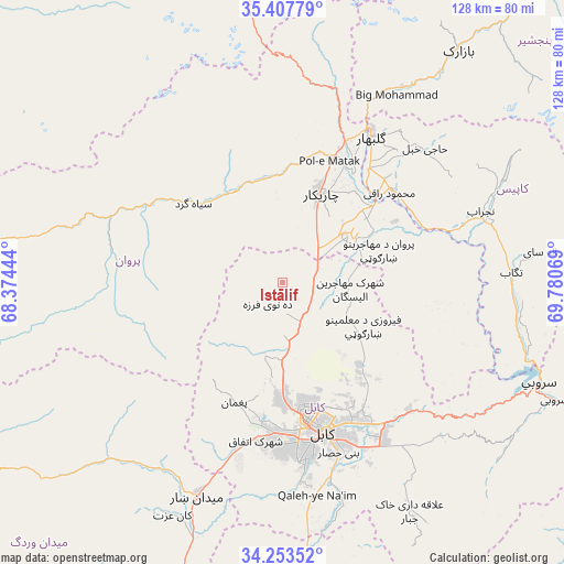
Istālif GPS coordinates[2]
34° 49' 57.648" North, 69° 4' 39.216" East
| Map corner | latitude | longitude |
|---|---|---|
| Upper-left | 35.40779°, | 68.37444° |
| Center: | 34.83268°, | 69.07756° |
| Lower-right: | 34.25352°, | 69.78069° |
| Map W x H: | 128.3×128.3 km | = 79.7×79.7mi |
| max Lat: | 38.4435° ⇑45.3% North |
| Istālif: | 34.83268° |
| min Lat: | ⇓54.7% South 30.15° |
| min Long | Istālif | max Long |
| 61.06667° | 69.07756° | 72.318° |
| W 60.8%⇐ | ⇒39.2% E |
Elevation
Elevation of Istālif is 1891 m = 6204 ft, and this is 472.6 m = 1551 ft above average elevation for this country.
| Max E: |
3068 m = 10066 ft | 30.5% |
| Istālif | 1891 m 6204 ft | |
| Avg. | 1418.4 m = 4654 ft | |
Min E: |
254 m = 833 ft | 69.5% |
See also: Afghanistan elevation on elevation.city.
Geographical zone
Istālif is located in North temperate zone (between Tropic of Cancer and the Arctic Circle). Distance of this Northern Tropic circle is 1267.1 km =787.3 mi to South.| Distance of | km | miles | from Istālif |
|---|---|---|---|
| North Pole | 6134 | 3811.5 | to North |
| Arctic Circle | 3528.1 | 2192.3 | to North |
| Tropic Cancer | 1267.1 | 787.3 | to South |
| Equator | 3873 | 2406.6 | to South |


Nearby cities:
15 places around Istālif: (largest is in red/bold)
• Chandal Bā’ī
29.8 km =18.5 mi,  202°
202°
• Charikar
21.9 km =13.6 mi,  23°
23°
• Deh-e Now
9.8 km =6.1 mi, 196°
• Ghulām ‘Alī
19 km =11.8 mi,  46°
46°
• Ibrāhīm Khān
29.5 km =18.3 mi,  33°
33°
• Kalakān
8.6 km =5.3 mi,  129°
129°
• Mīr Bachah Kōṯ
9.9 km =6.2 mi,  157°
157°
• Paghmān
29.6 km =18.4 mi, 203°
• Pul-e Sangī
30.8 km =19.1 mi,  147°
147°
• Qarah Bāgh Bāzār
8.8 km =5.5 mi,  75°
75°
• Qāshqāl
23.9 km =14.9 mi,  344°
344°
• Sidqābād
32.7 km =20.3 mi, 49°
• Siyāhgird
27.9 km =17.3 mi,  313°
313°
• Surkh Bilandī
17 km =10.6 mi, 195°
• Zargarān
5.3 km =3.3 mi, 198°
Sources, notices
• [Note1] Compared only with cities in Afghanistan existing in our database
• [Src1] Map data: © OpenStreetMap contributors (CC-BY-SA)
• [Src2] Other city data from geonames.org with taken over terms of usage.
• [Src3] Geographical zone / Annual Mean Temperature by Robert A. Rohde @ Wikipedia
