Qal‘ah-ye Na‘īm geodata
Qal‘ah-ye Na‘īm (Kabul) is a seat of a second-order administrative division; located in Afghanistan in Asia/Kabul (GMT+4.5) time zone. In our database, there are 93 cities with bigger population. Compared to other cities in Afghanistan, 56.9% of cities are located further ↑North; 63.7% of cities are located further ←West and 66.9% of cities have lower elevation than Qal‘ah-ye Na‘īm. Note1


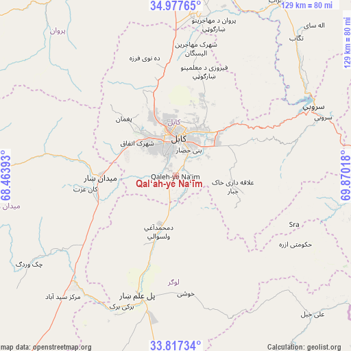
Qal‘ah-ye Na‘īm GPS coordinates[2]
34° 23' 58.236" North, 69° 10' 1.38" East
| Map corner | latitude | longitude |
|---|---|---|
| Upper-left | 34.97765°, | 68.46393° |
| Center: | 34.39951°, | 69.16705° |
| Lower-right: | 33.81734°, | 69.87018° |
| Map W x H: | 129×129 km | = 80.2×80.2mi |
| max Lat: | 38.4435° ⇑56.9% North |
| Qal‘ah-ye Na‘īm: | 34.39951° |
| min Lat: | ⇓43.1% South 30.15° |
| min Long | Qal‘ah-ye Na� | max Long |
| 61.06667° | 69.16705° | 72.318° |
| W 63.7%⇐ | ⇒36.3% E |
Elevation
Elevation of Qal‘ah-ye Na‘īm is 1819 m = 5968 ft, and this is 400.6 m = 1314 ft above average elevation for this country.
| Max E: |
3068 m = 10066 ft | 33.1% |
| Qal‘ah-ye Na‘īm | 1819 m 5968 ft | |
| Avg. | 1418.4 m = 4654 ft | |
Min E: |
254 m = 833 ft | 66.9% |
See also: Afghanistan elevation on elevation.city.
Geographical zone
Qal‘ah-ye Na‘īm is located in North temperate zone (between Tropic of Cancer and the Arctic Circle). Distance of this Northern Tropic circle is 1218.9 km =757.4 mi to South.| Distance of | km | miles | from Qal‘ah-ye Na‘īm |
|---|---|---|---|
| North Pole | 6182.2 | 3841.4 | to North |
| Arctic Circle | 3576.3 | 2222.2 | to North |
| Tropic Cancer | 1218.9 | 757.4 | to South |
| Equator | 3824.9 | 2376.7 | to South |


Nearby cities:
15 places around Qal‘ah-ye Na‘īm: (largest is in red/bold)
• Bagrāmī
14.4 km =8.9 mi,  43°
43°
• Chakaray
25.7 km =16 mi,  104°
104°
• Chandal Bā’ī
28.3 km =17.6 mi,  316°
316°
• Deh-e Now
40.2 km =25 mi,  344°
344°
• Kabul
14.3 km =8.9 mi,  1°
1°
• Kalakān
42.7 km =26.5 mi,  357°
357°
• Khōshī
44.7 km =27.8 mi,  174°
174°
• Maydanshakhr
27.6 km =17.1 mi,  269°
269°
• Muḩammad Āghah Wuluswālī
21.5 km =13.4 mi,  196°
196°
• Mīr Bachah Kōṯ
39.2 km =24.4 mi,  353°
353°
• Paghmān
28.8 km =17.9 mi, 316°
• Pul-e Sangī
23.8 km =14.8 mi,  20°
20°
• Pul-e ‘Alam
46.9 km =29.1 mi, 196°
• Surkh Bilandī
34.2 km =21.3 mi, 338°
• Zargarān
44.3 km =27.5 mi, 347°
Sources, notices
• [Note1] Compared only with cities in Afghanistan existing in our database
• [Src1] Map data: © OpenStreetMap contributors (CC-BY-SA)
• [Src2] Other city data from geonames.org with taken over terms of usage.
• [Src3] Geographical zone / Annual Mean Temperature by Robert A. Rohde @ Wikipedia
