Markaz-e Woluswalī-ye Āchīn geodata
Markaz-e Woluswalī-ye Āchīn (Nangarhar) is a populated place; located in Afghanistan in Asia/Kabul (GMT+4.5) time zone. With population of 15,098 people, there are 45 cities with bigger population in this country. Compared to other cities in Afghanistan, 64.6% of cities are located further ↑North; 91% of cities are located further ←West and 67.2% of cities have higher elevation than Markaz-e Woluswalī-ye Āchīn. Note1
Current local time in Markaz-e Woluswalī-ye Āchīn:
12:33 AM, WednesdayDifference from your time zone: hours


Markaz-e Woluswalī-ye Āchīn GPS coordinates[2]
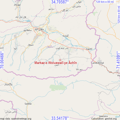
34° 7' 32.988" North, 70° 42' 28.008" East
| Map corner | latitude | longitude |
|---|---|---|
| Upper-left | 34.70587°, | 70.00466° |
| Center: | 34.12583°, | 70.70778° |
| Lower-right: | 33.54178°, | 71.41091° |
| Map W x H: | 129.4×129.4 km | = 80.4×80.4mi |
| max Lat: | 38.4435° ⇑64.6% North |
| Markaz-e Woluswalī-ye Āchīn: | 34.12583° |
| min Lat: | ⇓35.4% South 30.15° |
| min Long | Markaz-e Wolusw | max Long |
| 61.06667° | 70.70778° | 72.318° |
| W 91%⇐ | ⇒9% E |
Elevation
Elevation of Markaz-e Woluswalī-ye Āchīn is 972 m = 3189 ft, and this is 446.4 m = 1465 ft below average elevation for this country.
| Max E: |
3068 m = 10066 ft | 67.2% |
| Avg. | 1418.4 m = 4654 ft | |
| Markaz-e Woluswalī-ye Āchīn | 972 m = 3189 ft | |
Min E: |
254 m = 833 ft | 32.8% |
See also: Afghanistan elevation on elevation.city.
Geographical zone
Markaz-e Woluswalī-ye Āchīn is located in North temperate zone (between Tropic of Cancer and the Arctic Circle). Distance of this Northern Tropic circle is 1188.5 km =738.5 mi to South.| Distance of | km | miles | from Markaz-e Woluswalī-ye Āchīn |
|---|---|---|---|
| North Pole | 6212.6 | 3860.3 | to North |
| Arctic Circle | 3606.7 | 2241.1 | to North |
| Tropic Cancer | 1188.5 | 738.5 | to South |
| Equator | 3794.4 | 2357.7 | to South |


Nearby cities:
15 places around Markaz-e Woluswalī-ye Āchīn: (largest is in red/bold)
• Bāsawul
20.3 km =12.6 mi,  48°
48°
• Gōshtah
26.3 km =16.3 mi,  11°
11°
• Jalālābād
40.9 km =25.4 mi,  324°
324°
• Kai
1 km =0.6 mi,  74°
74°
• Kaz̲h̲ah
50 km =31.1 mi,  284°
284°
• Khafizan
35.6 km =22.1 mi,  300°
300°
• Kōṯowāl
22.9 km =14.2 mi,  263°
263°
• Nūrgal
54.5 km =33.9 mi, 5°
• Pachīr wa Āgām
40.4 km =25.1 mi, 281°
• Qal‘ah-ye Shāhī
59.2 km =36.8 mi,  349°
349°
• Qarghah’ī
63.9 km =39.7 mi, 318°
• Sangar Sarāy
31.9 km =19.8 mi, 348°
• Sheywah
50.8 km =31.6 mi, 347°
• Sulţānpūr-e ‘Ulyā
49.4 km =30.7 mi,  310°
310°
• Tsowkêy
66.1 km =41.1 mi,  17°
17°
Sources, notices
• [Note1] Compared only with cities in Afghanistan existing in our database
• [Src1] Map data: © OpenStreetMap contributors (CC-BY-SA)
• [Src2] Other city data from geonames.org with taken over terms of usage.
• [Src3] Geographical zone / Annual Mean Temperature by Robert A. Rohde @ Wikipedia
