Bāsawul geodata
Bāsawul (Nangarhar) is a seat of a second-order administrative division; located in Afghanistan in Asia/Kabul (GMT+4.5) time zone. With population of 6,835 people, there are 82 cities with bigger population in this country. Compared to other cities in Afghanistan, 61.1% of cities are located further ↑North; 94.2% of cities are located further ←West and 90.4% of cities have higher elevation than Bāsawul. Note1


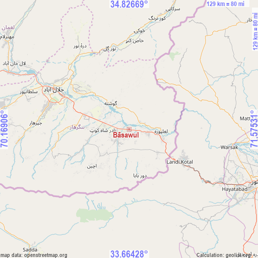
Bāsawul GPS coordinates[2]
34° 14' 50.964" North, 70° 52' 19.848" East
| Map corner | latitude | longitude |
|---|---|---|
| Upper-left | 34.82669°, | 70.16906° |
| Center: | 34.24749°, | 70.87218° |
| Lower-right: | 33.66428°, | 71.57531° |
| Map W x H: | 129.2×129.2 km | = 80.3×80.3mi |
| max Lat: | 38.4435° ⇑61.1% North |
| Bāsawul: | 34.24749° |
| min Lat: | ⇓38.9% South 30.15° |
| min Long | Bāsawul | max Long |
| 61.06667° | 70.87218° | 72.318° |
| W 94.2%⇐ | ⇒5.8% E |
Elevation
Elevation of Bāsawul is 464 m = 1522 ft, and this is 954.4 m = 3131 ft below average elevation for this country.
| Max E: |
3068 m = 10066 ft | 90.4% |
| Avg. | 1418.4 m = 4654 ft | |
| Bāsawul | 464 m = 1522 ft | |
Min E: |
254 m = 833 ft | 9.6% |
See also: Afghanistan elevation on elevation.city.
Geographical zone
Bāsawul is located in North temperate zone (between Tropic of Cancer and the Arctic Circle). Distance of this Northern Tropic circle is 1202 km =746.9 mi to South.| Distance of | km | miles | from Bāsawul |
|---|---|---|---|
| North Pole | 6199.1 | 3851.9 | to North |
| Arctic Circle | 3593.2 | 2232.7 | to North |
| Tropic Cancer | 1202 | 746.9 | to South |
| Equator | 3808 | 2366.2 | to South |


Nearby cities:
15 places around Bāsawul: (largest is in red/bold)
• Gōshtah
15.9 km =9.9 mi,  320°
320°
• Jalālābād
43.4 km =27 mi,  297°
297°
• Kai
19.4 km =12.1 mi,  226°
226°
• Kaz̲h̲ah
63.4 km =39.4 mi,  269°
269°
• Khafizan
46.1 km =28.6 mi,  275°
275°
• Kōṯowāl
41.1 km =25.5 mi,  247°
247°
• Markaz-e Woluswalī-ye Āchīn
20.3 km =12.6 mi, 228°
• Narang
59.2 km =36.8 mi,  15°
15°
• Nūrgal
41.9 km =26 mi,  346°
346°
• Pachīr wa Āgām
54.9 km =34.1 mi,  264°
264°
• Qal‘ah-ye Shāhī
51.6 km =32.1 mi,  330°
330°
• Sangar Sarāy
27.8 km =17.3 mi,  309°
309°
• Sheywah
44.5 km =27.7 mi, 324°
• Sulţānpūr-e ‘Ulyā
56 km =34.8 mi,  289°
289°
• Tsowkêy
49.7 km =30.9 mi,  5°
5°
Sources, notices
• [Note1] Compared only with cities in Afghanistan existing in our database
• [Src1] Map data: © OpenStreetMap contributors (CC-BY-SA)
• [Src2] Other city data from geonames.org with taken over terms of usage.
• [Src3] Geographical zone / Annual Mean Temperature by Robert A. Rohde @ Wikipedia
