Āsmār geodata
Āsmār (Kunar) is a seat of a second-order administrative division; located in Afghanistan in Asia/Kabul (GMT+4.5) time zone. With population of 15,708 people, there are 42 cities with bigger population in this country. Compared to other cities in Afghanistan, 61.7% of cities are located further ↓South; 98.7% of cities are located further ←West and 71.1% of cities have higher elevation than Āsmār. Note1


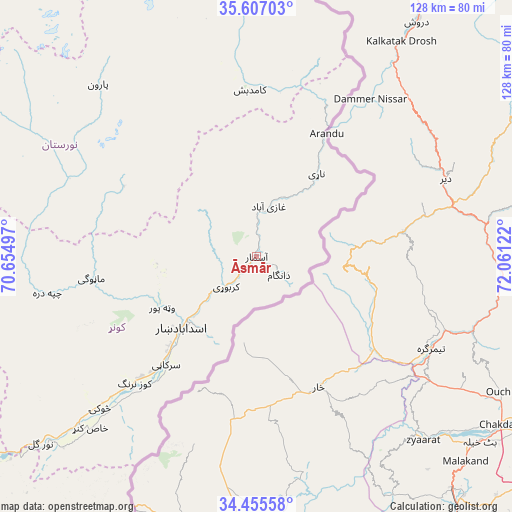
Āsmār GPS coordinates[2]
35° 1' 59.988" North, 71° 21' 29.124" East
| Map corner | latitude | longitude |
|---|---|---|
| Upper-left | 35.60703°, | 70.65497° |
| Center: | 35.03333°, | 71.35809° |
| Lower-right: | 34.45558°, | 72.06122° |
| Map W x H: | 128×128 km | = 79.5×79.5mi |
| max Lat: | 38.4435° ⇑38.3% North |
| Āsmār: | 35.03333° |
| min Lat: | ⇓61.7% South 30.15° |
| min Long | Āsmār | max Long |
| 61.06667° | 71.35809° | 72.318° |
| W 98.7%⇐ | ⇒1.3% E |
Elevation
Elevation of Āsmār is 913 m = 2995 ft, and this is 505.4 m = 1658 ft below average elevation for this country.
| Max E: |
3068 m = 10066 ft | 71.1% |
| Avg. | 1418.4 m = 4654 ft | |
| Āsmār | 913 m = 2995 ft | |
Min E: |
254 m = 833 ft | 28.9% |
See also: Afghanistan elevation on elevation.city.
Geographical zone
Āsmār is located in North temperate zone (between Tropic of Cancer and the Arctic Circle). Distance of this Northern Tropic circle is 1289.4 km =801.2 mi to South.| Distance of | km | miles | from Āsmār |
|---|---|---|---|
| North Pole | 6111.7 | 3797.6 | to North |
| Arctic Circle | 3505.8 | 2178.4 | to North |
| Tropic Cancer | 1289.4 | 801.2 | to South |
| Equator | 3895.3 | 2420.4 | to South |


Nearby cities:
15 places around Āsmār: (largest is in red/bold)
• Asadābād
26.2 km =16.3 mi,  227°
227°
• Barg-e Matāl
71.1 km =44.2 mi,  358°
358°
• Dāngām
7.2 km =4.5 mi,  129°
129°
• Kanḏay
53.5 km =33.2 mi,  260°
260°
• Karbori
10.7 km =6.6 mi, 225°
• Manogay
40.8 km =25.4 mi, 263°
• Narang
41.5 km =25.8 mi,  223°
223°
• Nāṟay
25.6 km =15.9 mi,  35°
35°
• Nūrgal
71.5 km =44.4 mi, 229°
• Pārūn
58.5 km =36.4 mi,  317°
317°
• Qal‘ah-ye Shāhī
82 km =51 mi,  238°
238°
• Sar Kāṉī
35.3 km =21.9 mi, 219°
• Sheywah
87 km =54.1 mi, 233°
• Tsowkêy
54.6 km =33.9 mi, 226°
• Wuṯahpūr
26.8 km =16.7 mi, 241°
Sources, notices
• [Note1] Compared only with cities in Afghanistan existing in our database
• [Src1] Map data: © OpenStreetMap contributors (CC-BY-SA)
• [Src2] Other city data from geonames.org with taken over terms of usage.
• [Src3] Geographical zone / Annual Mean Temperature by Robert A. Rohde @ Wikipedia
