Avshar geodata
Avshar (Ararat) is a populated place; located in Armenia in Asia/Yerevan (GMT+4) time zone. With population of 4,215 people, there are 58 cities with bigger population in this country. Compared to other cities in Armenia, 88.9% of cities are located further ↑North; 62.7% of cities are located further ←West and 92.4% of cities have higher elevation than Avshar. Note1


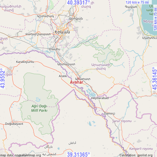
Avshar GPS coordinates[2]
39° 51' 19.908" North, 44° 39' 29.952" East
| Map corner | latitude | longitude |
|---|---|---|
| Upper-left | 40.39317°, | 43.9552° |
| Center: | 39.85553°, | 44.65832° |
| Lower-right: | 39.31365°, | 45.36145° |
| Map W x H: | 120×120 km | = 74.6×74.6mi |
| max Lat: | 41.24358° ⇑88.9% North |
| Avshar: | 39.85553° |
| min Lat: | ⇓11.1% South 38.90292° |
| min Long | Avshar | max Long |
| 43.74722° | 44.65832° | 46.5446° |
| W 62.7%⇐ | ⇒37.3% E |
Elevation
Elevation of Avshar is 832 m = 2730 ft, and this is 469.5 m = 1540 ft below average elevation for this country.
| Max E: |
2169 m = 7116 ft | 92.4% |
| Avg. | 1301.5 m = 4270 ft | |
| Avshar | 832 m = 2730 ft | |
Min E: |
440 m = 1444 ft | 7.6% |
See also: Armenia elevation on elevation.city.
Geographical zone
Avshar is located in North temperate zone (between Tropic of Cancer and the Arctic Circle). Distance of this Northern Tropic circle is 1825.6 km =1134.4 mi to South.| Distance of | km | miles | from Avshar |
|---|---|---|---|
| North Pole | 5575.5 | 3464.5 | to North |
| Arctic Circle | 2969.7 | 1845.3 | to North |
| Tropic Cancer | 1825.6 | 1134.4 | to South |
| Equator | 4431.5 | 2753.6 | to South |


Nearby cities:
15 places around Avshar: (largest is in red/bold)
• Aralez
5 km =3.1 mi,  357°
357°
• Ararat
4.9 km =3 mi,  124°
124°
• Aygavan
2.2 km =1.4 mi,  26°
26°
• Aygepat
12.5 km =7.8 mi,  336°
336°
• Aygezard
12 km =7.5 mi, 336°
• Goravan
8.7 km =5.4 mi,  47°
47°
• Lusarrat
6.4 km =4 mi,  288°
288°
• Noyakert
2.9 km =1.8 mi,  160°
160°
• Shahumyan
12.1 km =7.5 mi,  322°
322°
• Sisavan
5.9 km =3.7 mi,  7°
7°
• Surenavan
12.1 km =7.5 mi, 124°
• Vedi
8.6 km =5.3 mi,  41°
41°
• Vosketap’
3 km =1.9 mi, 344°
• Vostan
14.8 km =9.2 mi,  325°
325°
• Yeghegnavan
3.8 km =2.4 mi,  240°
240°
Sources, notices
• [Note1] Compared only with cities in Armenia existing in our database
• [Src1] Map data: © OpenStreetMap contributors (CC-BY-SA)
• [Src2] Other city data from geonames.org with taken over terms of usage.
• [Src3] Geographical zone / Annual Mean Temperature by Robert A. Rohde @ Wikipedia
