Ararat geodata
Ararat is a populated place; located in Armenia in Asia/Yerevan (GMT+4) time zone. With population of 28,832 people, there are 7 cities with bigger population in this country. Compared to other cities in Armenia, 90.4% of cities are located further ↑North; 66.9% of cities are located further ←West and 94.6% of cities have higher elevation than Ararat. Note1


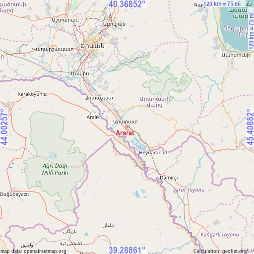
Ararat GPS coordinates[2]
39° 49' 50.484" North, 44° 42' 20.484" East
| Map corner | latitude | longitude |
|---|---|---|
| Upper-left | 40.36852°, | 44.00257° |
| Center: | 39.83069°, | 44.70569° |
| Lower-right: | 39.28861°, | 45.40882° |
| Map W x H: | 120.1×120.1 km | = 74.6×74.6mi |
| max Lat: | 41.24358° ⇑90.4% North |
| Ararat: | 39.83069° |
| min Lat: | ⇓9.6% South 38.90292° |
| min Long | Ararat | max Long |
| 43.74722° | 44.70569° | 46.5446° |
| W 66.9%⇐ | ⇒33.1% E |
Elevation
Elevation of Ararat is 823 m = 2700 ft, and this is 478.5 m = 1570 ft below average elevation for this country.
| Max E: |
2169 m = 7116 ft | 94.6% |
| Avg. | 1301.5 m = 4270 ft | |
| Ararat | 823 m = 2700 ft | |
Min E: |
440 m = 1444 ft | 5.4% |
See also: Armenia elevation on elevation.city.
Geographical zone
Ararat is located in North temperate zone (between Tropic of Cancer and the Arctic Circle). Distance of this Northern Tropic circle is 1822.8 km =1132.6 mi to South.| Distance of | km | miles | from Ararat |
|---|---|---|---|
| North Pole | 5578.3 | 3466.2 | to North |
| Arctic Circle | 2972.4 | 1847 | to North |
| Tropic Cancer | 1822.8 | 1132.6 | to South |
| Equator | 4428.8 | 2751.9 | to South |


Nearby cities:
15 places around Ararat: (largest is in red/bold)
• Aralez
8.8 km =5.5 mi,  331°
331°
• Armash
11.5 km =7.1 mi,  128°
128°
• Avshar
4.9 km =3 mi,  304°
304°
• Aygavan
5.6 km =3.5 mi, 327°
• Aygepat
16.8 km =10.4 mi, 327°
• Aygezard
16.3 km =10.1 mi, 327°
• Goravan
8.9 km =5.5 mi,  15°
15°
• Lusarrat
11.2 km =7 mi, 295°
• Noyakert
3.1 km =1.9 mi,  270°
270°
• Shahumyan
16.8 km =10.4 mi,  317°
317°
• Sisavan
9.2 km =5.7 mi,  339°
339°
• Surenavan
7.2 km =4.5 mi,  124°
124°
• Vedi
9.4 km =5.8 mi,  10°
10°
• Vosketap’
7.4 km =4.6 mi, 319°
• Yeghegnavan
7.4 km =4.6 mi,  277°
277°
Sources, notices
• [Note1] Compared only with cities in Armenia existing in our database
• [Src1] Map data: © OpenStreetMap contributors (CC-BY-SA)
• [Src2] Other city data from geonames.org with taken over terms of usage.
• [Src3] Geographical zone / Annual Mean Temperature by Robert A. Rohde @ Wikipedia
