Tsaghkahovit geodata
Tsaghkahovit (Aragatsotn) is a populated place; located in Armenia in Asia/Yerevan (GMT+4) time zone. With population of 1,551 people, there are 216 cities with bigger population in this country. Compared to other cities in Armenia, 75.2% of cities are located further ↓South; 78.3% of cities are located further →East and 99% of cities have lower elevation than Tsaghkahovit. Note1


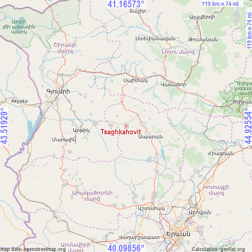
Tsaghkahovit GPS coordinates[2]
40° 38' 3.408" North, 44° 13' 20.676" East
| Map corner | latitude | longitude |
|---|---|---|
| Upper-left | 41.16573°, | 43.51929° |
| Center: | 40.63428°, | 44.22241° |
| Lower-right: | 40.09856°, | 44.92554° |
| Map W x H: | 118.7×118.7 km | = 73.8×73.8mi |
| max Lat: | 41.24358° ⇑24.8% North |
| Tsaghkahovit: | 40.63428° |
| min Lat: | ⇓75.2% South 38.90292° |
| min Long | Tsaghkahovit | max Long |
| 43.74722° | 44.22241° | 46.5446° |
| W 21.7%⇐ | ⇒78.3% E |
Elevation
Elevation of Tsaghkahovit is 2108 m = 6916 ft, and this is 806.5 m = 2646 ft above average elevation for this country.
| Max E: |
2169 m = 7116 ft | 1% |
| Tsaghkahovit | 2108 m 6916 ft | |
| Avg. | 1301.5 m = 4270 ft | |
Min E: |
440 m = 1444 ft | 99% |
See also: Armenia elevation on elevation.city.
Geographical zone
Tsaghkahovit is located in North temperate zone (between Tropic of Cancer and the Arctic Circle). Distance of this Northern Tropic circle is 1912.2 km =1188.2 mi to South.| Distance of | km | miles | from Tsaghkahovit |
|---|---|---|---|
| North Pole | 5489 | 3410.7 | to North |
| Arctic Circle | 2883.1 | 1791.5 | to North |
| Tropic Cancer | 1912.2 | 1188.2 | to South |
| Equator | 4518.1 | 2807.4 | to South |


Nearby cities:
15 places around Tsaghkahovit: (largest is in red/bold)
• Anushavan
20.5 km =12.7 mi,  274°
274°
• Aparan
12.4 km =7.7 mi,  111°
111°
• Aragats
19.6 km =12.2 mi,  145°
145°
• Arevshat
15.2 km =9.4 mi,  278°
278°
• Hnaberd
6.9 km =4.3 mi, 272°
• Jrashen
17.6 km =10.9 mi,  350°
350°
• Kasakh
19.2 km =11.9 mi,  124°
124°
• Lerrnants’k’
18.4 km =11.4 mi,  13°
13°
• Lerrnavan
17.9 km =11.1 mi,  342°
342°
• Mets Mant’ash
14 km =8.7 mi, 274°
• P’ok’r Mant’ash
14.8 km =9.2 mi, 272°
• Saramej
15.6 km =9.7 mi,  359°
359°
• Shenavan
21.6 km =13.4 mi,  140°
140°
• Spandaryan
17.7 km =11 mi, 279°
• Tsaghkaber
20.9 km =13 mi,  330°
330°
Sources, notices
• [Note1] Compared only with cities in Armenia existing in our database
• [Src1] Map data: © OpenStreetMap contributors (CC-BY-SA)
• [Src2] Other city data from geonames.org with taken over terms of usage.
• [Src3] Geographical zone / Annual Mean Temperature by Robert A. Rohde @ Wikipedia
