Aragats geodata
Aragats (Aragatsotn) is a populated place; located in Armenia in Asia/Yerevan (GMT+4) time zone. With population of 2,707 people, there are 105 cities with bigger population in this country. Compared to other cities in Armenia, 67.8% of cities are located further ↓South; 68.2% of cities are located further →East and 93.6% of cities have lower elevation than Aragats. Note1


Aragats GPS coordinates[2]
40° 29' 20.004" North, 44° 21' 10.44" East
| Map corner | latitude | longitude |
|---|---|---|
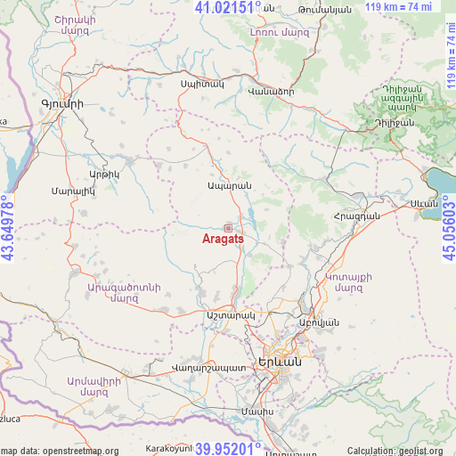
| Upper-left | 41.02151°, | 43.64978° |
| Center: | 40.48889°, | 44.3529° |
| Lower-right: | 39.95201°, | 45.05603° |
| Map W x H: | 118.9×118.9 km | = 73.9×73.9mi |
| max Lat: | 41.24358° ⇑32.2% North |
| Aragats: | 40.48889° |
| min Lat: | ⇓67.8% South 38.90292° |
| min Long | Aragats | max Long |
| 43.74722° | 44.3529° | 46.5446° |
| W 31.8%⇐ | ⇒68.2% E |
Elevation
Elevation of Aragats is 1976 m = 6483 ft, and this is 674.5 m = 2213 ft above average elevation for this country.
| Max E: |
2169 m = 7116 ft | 6.4% |
| Aragats | 1976 m 6483 ft | |
| Avg. | 1301.5 m = 4270 ft | |
Min E: |
440 m = 1444 ft | 93.6% |
See also: Armenia elevation on elevation.city.
Geographical zone
Aragats is located in North temperate zone (between Tropic of Cancer and the Arctic Circle). Distance of this Northern Tropic circle is 1896 km =1178.1 mi to South.| Distance of | km | miles | from Aragats |
|---|---|---|---|
| North Pole | 5505.1 | 3420.7 | to North |
| Arctic Circle | 2899.2 | 1801.5 | to North |
| Tropic Cancer | 1896 | 1178.1 | to South |
| Equator | 4501.9 | 2797.4 | to South |


Nearby cities:
15 places around Aragats: (largest is in red/bold)
• Aparan
11.6 km =7.2 mi,  2°
2°
• Aragyugh
18.8 km =11.7 mi,  120°
120°
• Arzakan
22 km =13.7 mi,  101°
101°
• Ashtarak
21.1 km =13.1 mi,  177°
177°
• Buzhakan
14.6 km =9.1 mi, 104°
• Byurakan
18 km =11.2 mi,  202°
202°
• Karbi
17.7 km =11 mi,  173°
173°
• Kasakh
7.2 km =4.5 mi,  42°
42°
• Nor Yerznka
21.2 km =13.2 mi, 171°
• Shenavan
2.7 km =1.7 mi, 103°
• Tsaghkahovit
19.6 km =12.2 mi,  325°
325°
• Ushi
15.9 km =9.9 mi, 173°
• Yeghvard
21.4 km =13.3 mi,  148°
148°
• Zoravan
20.6 km =12.8 mi,  135°
135°
• Zovuni
7.7 km =4.8 mi,  71°
71°
Sources, notices
• [Note1] Compared only with cities in Armenia existing in our database
• [Src1] Map data: © OpenStreetMap contributors (CC-BY-SA)
• [Src2] Other city data from geonames.org with taken over terms of usage.
• [Src3] Geographical zone / Annual Mean Temperature by Robert A. Rohde @ Wikipedia
