Aparan geodata
Aparan (Aragatsotn) is a populated place; located in Armenia in Asia/Yerevan (GMT+4) time zone. With population of 5,670 people, there are 36 cities with bigger population in this country. Compared to other cities in Armenia, 73.9% of cities are located further ↓South; 67.8% of cities are located further →East and 86.3% of cities have lower elevation than Aparan. Note1


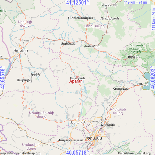
Aparan GPS coordinates[2]
40° 35' 35.628" North, 44° 21' 32.04" East
| Map corner | latitude | longitude |
|---|---|---|
| Upper-left | 41.12501°, | 43.65578° |
| Center: | 40.59323°, | 44.3589° |
| Lower-right: | 40.05718°, | 45.06203° |
| Map W x H: | 118.7×118.7 km | = 73.8×73.8mi |
| max Lat: | 41.24358° ⇑26.1% North |
| Aparan: | 40.59323° |
| min Lat: | ⇓73.9% South 38.90292° |
| min Long | Aparan | max Long |
| 43.74722° | 44.3589° | 46.5446° |
| W 32.2%⇐ | ⇒67.8% E |
Elevation
Elevation of Aparan is 1892 m = 6207 ft, and this is 590.5 m = 1937 ft above average elevation for this country.
| Max E: |
2169 m = 7116 ft | 13.7% |
| Aparan | 1892 m 6207 ft | |
| Avg. | 1301.5 m = 4270 ft | |
Min E: |
440 m = 1444 ft | 86.3% |
See also: Armenia elevation on elevation.city.
Geographical zone
Aparan is located in North temperate zone (between Tropic of Cancer and the Arctic Circle). Distance of this Northern Tropic circle is 1907.6 km =1185.3 mi to South.| Distance of | km | miles | from Aparan |
|---|---|---|---|
| North Pole | 5493.5 | 3413.5 | to North |
| Arctic Circle | 2887.6 | 1794.3 | to North |
| Tropic Cancer | 1907.6 | 1185.3 | to South |
| Equator | 4513.5 | 2804.6 | to South |


Nearby cities:
15 places around Aparan: (largest is in red/bold)
• Aragats
11.6 km =7.2 mi,  182°
182°
• Aragyugh
26.3 km =16.3 mi,  143°
143°
• Buzhakan
20.4 km =12.7 mi, 138°
• Hnaberd
19.1 km =11.9 mi,  284°
284°
• Kasakh
7.6 km =4.7 mi,  145°
145°
• Lerrnants’k’
23.6 km =14.7 mi,  342°
342°
• Lerrnapat
24.9 km =15.5 mi,  6°
6°
• Meghradzor
24.7 km =15.3 mi,  86°
86°
• Mets Mant’ash
26.1 km =16.2 mi, 282°
• Saramej
23.3 km =14.5 mi,  330°
330°
• Shahumyan
25.6 km =15.9 mi,  37°
37°
• Shenavan
12.4 km =7.7 mi,  170°
170°
• Tsaghkahovit
12.4 km =7.7 mi,  291°
291°
• Vanadzor
26.1 km =16.2 mi,  25°
25°
• Zovuni
11.4 km =7.1 mi, 143°
Sources, notices
• [Note1] Compared only with cities in Armenia existing in our database
• [Src1] Map data: © OpenStreetMap contributors (CC-BY-SA)
• [Src2] Other city data from geonames.org with taken over terms of usage.
• [Src3] Geographical zone / Annual Mean Temperature by Robert A. Rohde @ Wikipedia
