Metsavan geodata
Metsavan (Lori) is a populated place; located in Armenia in Asia/Yerevan (GMT+4) time zone. With population of 4,767 people, there are 47 cities with bigger population in this country. Compared to other cities in Armenia, 99.4% of cities are located further ↓South; 78% of cities are located further →East and 68.8% of cities have lower elevation than Metsavan. Note1


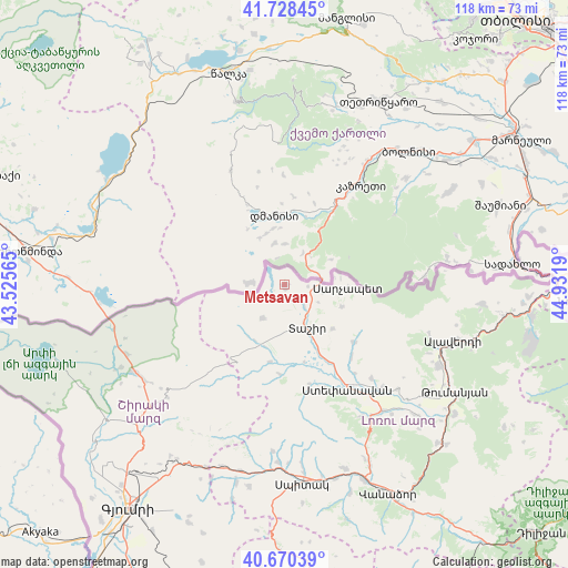
Metsavan GPS coordinates[2]
41° 12' 5.616" North, 44° 13' 43.572" East
| Map corner | latitude | longitude |
|---|---|---|
| Upper-left | 41.72845°, | 43.52565° |
| Center: | 41.20156°, | 44.22877° |
| Lower-right: | 40.67039°, | 44.9319° |
| Map W x H: | 117.6×117.6 km | = 73.1×73.1mi |
| max Lat: | 41.24358° ⇑0.6% North |
| Metsavan: | 41.20156° |
| min Lat: | ⇓99.4% South 38.90292° |
| min Long | Metsavan | max Long |
| 43.74722° | 44.22877° | 46.5446° |
| W 22%⇐ | ⇒78% E |
Elevation
Elevation of Metsavan is 1576 m = 5171 ft, and this is 274.5 m = 901 ft above average elevation for this country.
| Max E: |
2169 m = 7116 ft | 31.2% |
| Metsavan | 1576 m 5171 ft | |
| Avg. | 1301.5 m = 4270 ft | |
Min E: |
440 m = 1444 ft | 68.8% |
See also: Armenia elevation on elevation.city.
Geographical zone
Metsavan is located in North temperate zone (between Tropic of Cancer and the Arctic Circle). Distance of this Northern Tropic circle is 1975.3 km =1227.4 mi to South.| Distance of | km | miles | from Metsavan |
|---|---|---|---|
| North Pole | 5425.9 | 3371.5 | to North |
| Arctic Circle | 2820 | 1752.3 | to North |
| Tropic Cancer | 1975.3 | 1227.4 | to South |
| Equator | 4581.2 | 2846.6 | to South |


Nearby cities:
15 places around Metsavan: (largest is in red/bold)
• Agarak
29.2 km =18.1 mi,  136°
136°
• Alaverdi
39 km =24.2 mi,  107°
107°
• Arevashogh
38.1 km =23.7 mi,  174°
174°
• Bazum
41.1 km =25.5 mi,  154°
154°
• Gogaran
34.4 km =21.4 mi,  184°
184°
• Gyulagarak
33.1 km =20.6 mi, 142°
• Norashen
8.9 km =5.5 mi,  99°
99°
• Odzun
36.2 km =22.5 mi,  117°
117°
• Sarahart’
36.8 km =22.9 mi, 181°
• Shirakamut
38.4 km =23.9 mi,  189°
189°
• Spitak
41.2 km =25.6 mi, 175°
• Step’anavan
25 km =15.5 mi, 148°
• Tashir
10.1 km =6.3 mi, 152°
• Urrut
20.4 km =12.7 mi, 136°
• Vardablur
34.8 km =21.6 mi, 137°
Sources, notices
• [Note1] Compared only with cities in Armenia existing in our database
• [Src1] Map data: © OpenStreetMap contributors (CC-BY-SA)
• [Src2] Other city data from geonames.org with taken over terms of usage.
• [Src3] Geographical zone / Annual Mean Temperature by Robert A. Rohde @ Wikipedia
