Step’anavan geodata
Step’anavan (Lori) is a populated place; located in Armenia in Asia/Yerevan (GMT+4) time zone. With population of 23,782 people, there are 9 cities with bigger population in this country. Compared to other cities in Armenia, 94.9% of cities are located further ↓South; 64.3% of cities are located further →East and 55.7% of cities have lower elevation than Step’anavan. Note1


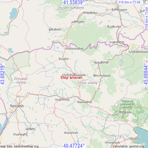
Step’anavan GPS coordinates[2]
41° 0' 35.82" North, 44° 23' 7.116" East
| Map corner | latitude | longitude |
|---|---|---|
| Upper-left | 41.53839°, | 43.68219° |
| Center: | 41.00995°, | 44.38531° |
| Lower-right: | 40.47724°, | 45.08844° |
| Map W x H: | 118×118 km | = 73.3×73.3mi |
| max Lat: | 41.24358° ⇑5.1% North |
| Step’anavan: | 41.00995° |
| min Lat: | ⇓94.9% South 38.90292° |
| min Long | Step’anavan | max Long |
| 43.74722° | 44.38531° | 46.5446° |
| W 35.7%⇐ | ⇒64.3% E |
Elevation
Elevation of Step’anavan is 1405 m = 4610 ft, and this is 103.5 m = 340 ft above average elevation for this country.
| Max E: |
2169 m = 7116 ft | 44.3% |
| Step’anavan | 1405 m 4610 ft | |
| Avg. | 1301.5 m = 4270 ft | |
Min E: |
440 m = 1444 ft | 55.7% |
See also: Armenia elevation on elevation.city.
Geographical zone
Step’anavan is located in North temperate zone (between Tropic of Cancer and the Arctic Circle). Distance of this Northern Tropic circle is 1954 km =1214.2 mi to South.| Distance of | km | miles | from Step’anavan |
|---|---|---|---|
| North Pole | 5447.2 | 3384.7 | to North |
| Arctic Circle | 2841.3 | 1765.5 | to North |
| Tropic Cancer | 1954 | 1214.2 | to South |
| Equator | 4559.9 | 2833.4 | to South |


Nearby cities:
15 places around Step’anavan: (largest is in red/bold)
• Agarak
7 km =4.3 mi,  89°
89°
• Arevashogh
19.1 km =11.9 mi,  209°
209°
• Bazum
16.5 km =10.3 mi,  163°
163°
• Darpas
19.5 km =12.1 mi,  170°
170°
• Gogaran
20.4 km =12.7 mi,  230°
230°
• Gyulagarak
8.7 km =5.4 mi,  123°
123°
• Lerrnapat
21.6 km =13.4 mi,  178°
178°
• Norashen
20.4 km =12.7 mi,  347°
347°
• Odzun
19.7 km =12.2 mi,  75°
75°
• Sarahart’
21.2 km =13.2 mi,  222°
222°
• Spitak
22.1 km =13.7 mi, 206°
• Tashir
14.9 km =9.3 mi,  325°
325°
• Urrut
6.5 km =4 mi,  8°
8°
• Vahagni
22 km =13.7 mi, 121°
• Vardablur
11.2 km =7 mi,  112°
112°
Sources, notices
• [Note1] Compared only with cities in Armenia existing in our database
• [Src1] Map data: © OpenStreetMap contributors (CC-BY-SA)
• [Src2] Other city data from geonames.org with taken over terms of usage.
• [Src3] Geographical zone / Annual Mean Temperature by Robert A. Rohde @ Wikipedia
