Bazum geodata
Bazum (Lori) is a populated place; located in Armenia in Asia/Yerevan (GMT+4) time zone. With population of 1,114 people, there are 283 cities with bigger population in this country. Compared to other cities in Armenia, 89.5% of cities are located further ↓South; 57% of cities are located further →East and 65% of cities have lower elevation than Bazum. Note1


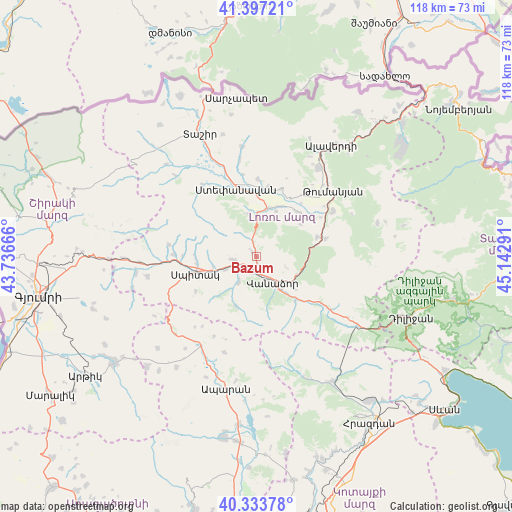
Bazum GPS coordinates[2]
40° 52' 3.468" North, 44° 26' 23.208" East
| Map corner | latitude | longitude |
|---|---|---|
| Upper-left | 41.39721°, | 43.73666° |
| Center: | 40.86763°, | 44.43978° |
| Lower-right: | 40.33378°, | 45.14291° |
| Map W x H: | 118.2×118.2 km | = 73.4×73.4mi |
| max Lat: | 41.24358° ⇑10.5% North |
| Bazum: | 40.86763° |
| min Lat: | ⇓89.5% South 38.90292° |
| min Long | Bazum | max Long |
| 43.74722° | 44.43978° | 46.5446° |
| W 43%⇐ | ⇒57% E |
Elevation
Elevation of Bazum is 1521 m = 4990 ft, and this is 219.5 m = 720 ft above average elevation for this country.
| Max E: |
2169 m = 7116 ft | 35% |
| Bazum | 1521 m 4990 ft | |
| Avg. | 1301.5 m = 4270 ft | |
Min E: |
440 m = 1444 ft | 65% |
See also: Armenia elevation on elevation.city.
Geographical zone
Bazum is located in North temperate zone (between Tropic of Cancer and the Arctic Circle). Distance of this Northern Tropic circle is 1938.1 km =1204.3 mi to South.| Distance of | km | miles | from Bazum |
|---|---|---|---|
| North Pole | 5463 | 3394.5 | to North |
| Arctic Circle | 2857.1 | 1775.3 | to North |
| Tropic Cancer | 1938.1 | 1204.3 | to South |
| Equator | 4544.1 | 2823.6 | to South |


Nearby cities:
15 places around Bazum: (largest is in red/bold)
• Agarak
16.1 km =10 mi,  8°
8°
• Arevashogh
13.9 km =8.6 mi,  266°
266°
• Darpas
3.7 km =2.3 mi,  199°
199°
• Gugark’
11 km =6.8 mi,  129°
129°
• Gyulagarak
11.4 km =7.1 mi, 13°
• Lerrnants’k’
16.1 km =10 mi,  239°
239°
• Lerrnapat
7 km =4.3 mi,  213°
213°
• Sarahart’
19 km =11.8 mi, 270°
• Shahumyan
13.6 km =8.5 mi,  139°
139°
• Spitak
15 km =9.3 mi,  254°
254°
• Step’anavan
16.5 km =10.3 mi,  343°
343°
• Vahagni
14.9 km =9.3 mi,  72°
72°
• Vanadzor
8.4 km =5.2 mi,  147°
147°
• Vardablur
12.9 km =8 mi,  26°
26°
• Yeghegnut
16.6 km =10.3 mi,  76°
76°
Sources, notices
• [Note1] Compared only with cities in Armenia existing in our database
• [Src1] Map data: © OpenStreetMap contributors (CC-BY-SA)
• [Src2] Other city data from geonames.org with taken over terms of usage.
• [Src3] Geographical zone / Annual Mean Temperature by Robert A. Rohde @ Wikipedia
