Odzun geodata
Odzun (Lori) is a populated place; located in Armenia in Asia/Yerevan (GMT+4) time zone. With population of 4,524 people, there are 52 cities with bigger population in this country. Compared to other cities in Armenia, 95.9% of cities are located further ↓South; 59.2% of cities are located further ←West and 56.4% of cities have higher elevation than Odzun. Note1


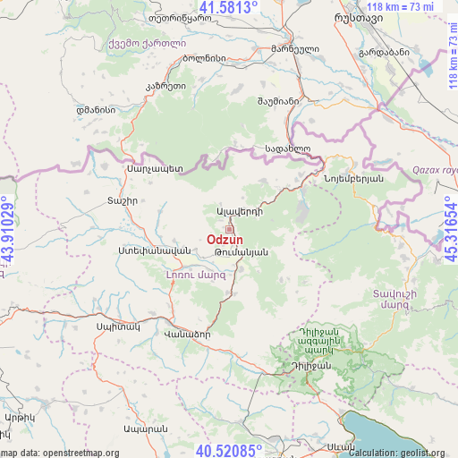
Odzun GPS coordinates[2]
41° 3' 11.556" North, 44° 36' 48.276" East
| Map corner | latitude | longitude |
|---|---|---|
| Upper-left | 41.5813°, | 43.91029° |
| Center: | 41.05321°, | 44.61341° |
| Lower-right: | 40.52085°, | 45.31654° |
| Map W x H: | 117.9×117.9 km | = 73.3×73.3mi |
| max Lat: | 41.24358° ⇑4.1% North |
| Odzun: | 41.05321° |
| min Lat: | ⇓95.9% South 38.90292° |
| min Long | Odzun | max Long |
| 43.74722° | 44.61341° | 46.5446° |
| W 59.2%⇐ | ⇒40.8% E |
Elevation
Elevation of Odzun is 1107 m = 3632 ft, and this is 194.5 m = 638 ft below average elevation for this country.
| Max E: |
2169 m = 7116 ft | 56.4% |
| Avg. | 1301.5 m = 4270 ft | |
| Odzun | 1107 m = 3632 ft | |
Min E: |
440 m = 1444 ft | 43.6% |
See also: Armenia elevation on elevation.city.
Geographical zone
Odzun is located in North temperate zone (between Tropic of Cancer and the Arctic Circle). Distance of this Northern Tropic circle is 1958.8 km =1217.1 mi to South.| Distance of | km | miles | from Odzun |
|---|---|---|---|
| North Pole | 5442.4 | 3381.7 | to North |
| Arctic Circle | 2836.5 | 1762.5 | to North |
| Tropic Cancer | 1958.8 | 1217.1 | to South |
| Equator | 4564.7 | 2836.4 | to South |


Nearby cities:
15 places around Odzun: (largest is in red/bold)
• Agarak
13 km =8.1 mi,  248°
248°
• Akht’ala
17.6 km =10.9 mi,  43°
43°
• Alaverdi
7 km =4.3 mi,  45°
45°
• Archis
25.2 km =15.7 mi,  60°
60°
• Bazum
25.3 km =15.7 mi,  215°
215°
• Chochkan
23.2 km =14.4 mi, 52°
• Dsegh
10.6 km =6.6 mi,  163°
163°
• Gyulagarak
15.3 km =9.5 mi,  231°
231°
• Lorut
18.5 km =11.5 mi,  134°
134°
• Shnogh
21.7 km =13.5 mi, 61°
• Step’anavan
19.7 km =12.2 mi,  255°
255°
• Urrut
18.3 km =11.4 mi,  275°
275°
• Vahagni
16.3 km =10.1 mi,  181°
181°
• Vardablur
12.7 km =7.9 mi, 223°
• Yeghegnut
16.8 km =10.4 mi,  174°
174°
Sources, notices
• [Note1] Compared only with cities in Armenia existing in our database
• [Src1] Map data: © OpenStreetMap contributors (CC-BY-SA)
• [Src2] Other city data from geonames.org with taken over terms of usage.
• [Src3] Geographical zone / Annual Mean Temperature by Robert A. Rohde @ Wikipedia
