Ijevan geodata
Ijevan (Tavush) is a seat of a first-order administrative division; located in Armenia in Asia/Yerevan (GMT+4) time zone. With population of 14,737 people, there are 18 cities with bigger population in this country. Compared to other cities in Armenia, 90.1% of cities are located further ↓South; 79.9% of cities are located further ←West and 98.7% of cities have higher elevation than Ijevan. Note1


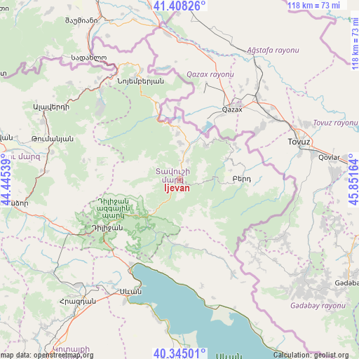
Ijevan GPS coordinates[2]
40° 52' 43.572" North, 45° 8' 54.636" East
| Map corner | latitude | longitude |
|---|---|---|
| Upper-left | 41.40826°, | 44.44539° |
| Center: | 40.87877°, | 45.14851° |
| Lower-right: | 40.34501°, | 45.85164° |
| Map W x H: | 118.2×118.2 km | = 73.4×73.4mi |
| max Lat: | 41.24358° ⇑9.9% North |
| Ijevan: | 40.87877° |
| min Lat: | ⇓90.1% South 38.90292° |
| min Long | Ijevan | max Long |
| 43.74722° | 45.14851° | 46.5446° |
| W 79.9%⇐ | ⇒20.1% E |
Elevation
Elevation of Ijevan is 677 m = 2221 ft, and this is 624.5 m = 2049 ft below average elevation for this country.
| Max E: |
2169 m = 7116 ft | 98.7% |
| Avg. | 1301.5 m = 4270 ft | |
| Ijevan | 677 m = 2221 ft | |
Min E: |
440 m = 1444 ft | 1.3% |
See also: Armenia elevation on elevation.city.
Geographical zone
Ijevan is located in North temperate zone (between Tropic of Cancer and the Arctic Circle). Distance of this Northern Tropic circle is 1939.4 km =1205.1 mi to South.| Distance of | km | miles | from Ijevan |
|---|---|---|---|
| North Pole | 5461.8 | 3393.8 | to North |
| Arctic Circle | 2855.9 | 1774.6 | to North |
| Tropic Cancer | 1939.4 | 1205.1 | to South |
| Equator | 4545.3 | 2824.3 | to South |


Nearby cities:
15 places around Ijevan: (largest is in red/bold)
• Artsvaberd
27.4 km =17 mi,  99°
99°
• Aygehovit
14.1 km =8.8 mi,  37°
37°
• Aygut
21.9 km =13.6 mi,  173°
173°
• Azatamut
11.9 km =7.4 mi,  15°
15°
• Berd
20.2 km =12.6 mi,  89°
89°
• Dilijan
29.4 km =18.3 mi,  238°
238°
• Gosh
20.7 km =12.9 mi,  217°
217°
• Haghartsin
19 km =11.8 mi,  233°
233°
• Khasht’arrak
7 km =4.3 mi, 23°
• Mosesgegh
28.7 km =17.8 mi,  84°
84°
• Navur
16.3 km =10.1 mi, 94°
• Parravak’ar
21.7 km =13.5 mi,  57°
57°
• Sarigyugh
17.4 km =10.8 mi,  358°
358°
• Tsovagyugh
31.5 km =19.6 mi,  210°
210°
• Voskevan
27.8 km =17.3 mi,  345°
345°
Sources, notices
• [Note1] Compared only with cities in Armenia existing in our database
• [Src1] Map data: © OpenStreetMap contributors (CC-BY-SA)
• [Src2] Other city data from geonames.org with taken over terms of usage.
• [Src3] Geographical zone / Annual Mean Temperature by Robert A. Rohde @ Wikipedia
