Tsovagyugh geodata
Tsovagyugh (Gegharkunik) is a populated place; located in Armenia in Asia/Yerevan (GMT+4) time zone. With population of 3,857 people, there are 69 cities with bigger population in this country. Compared to other cities in Armenia, 74.8% of cities are located further ↓South; 75.5% of cities are located further ←West and 96.5% of cities have lower elevation than Tsovagyugh. Note1


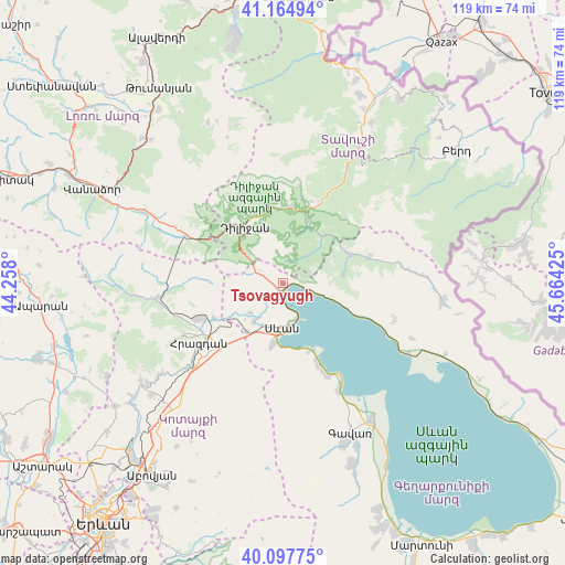
Tsovagyugh GPS coordinates[2]
40° 38' 0.528" North, 44° 57' 40.032" East
| Map corner | latitude | longitude |
|---|---|---|
| Upper-left | 41.16494°, | 44.258° |
| Center: | 40.63348°, | 44.96112° |
| Lower-right: | 40.09775°, | 45.66425° |
| Map W x H: | 118.7×118.7 km | = 73.8×73.8mi |
| max Lat: | 41.24358° ⇑25.2% North |
| Tsovagyugh: | 40.63348° |
| min Lat: | ⇓74.8% South 38.90292° |
| min Long | Tsovagyugh | max Long |
| 43.74722° | 44.96112° | 46.5446° |
| W 75.5%⇐ | ⇒24.5% E |
Elevation
Elevation of Tsovagyugh is 2016 m = 6614 ft, and this is 714.5 m = 2344 ft above average elevation for this country.
| Max E: |
2169 m = 7116 ft | 3.5% |
| Tsovagyugh | 2016 m 6614 ft | |
| Avg. | 1301.5 m = 4270 ft | |
Min E: |
440 m = 1444 ft | 96.5% |
See also: Armenia elevation on elevation.city.
Geographical zone
Tsovagyugh is located in North temperate zone (between Tropic of Cancer and the Arctic Circle). Distance of this Northern Tropic circle is 1912.1 km =1188.1 mi to South.| Distance of | km | miles | from Tsovagyugh |
|---|---|---|---|
| North Pole | 5489 | 3410.7 | to North |
| Arctic Circle | 2883.2 | 1791.5 | to North |
| Tropic Cancer | 1912.1 | 1188.1 | to South |
| Equator | 4518 | 2807.4 | to South |


Nearby cities:
15 places around Tsovagyugh: (largest is in red/bold)
• Aygut
19 km =11.8 mi,  73°
73°
• Ddmashen
13.6 km =8.5 mi,  238°
238°
• Dilijan
15.2 km =9.4 mi,  322°
322°
• Fioletovo
22.8 km =14.2 mi,  295°
295°
• Gagarin
12.9 km =8 mi,  216°
216°
• Geghamavan
10 km =6.2 mi, 217°
• Gosh
11.3 km =7 mi,  16°
16°
• Haghartsin
15.9 km =9.9 mi,  2°
2°
• Hrazdan
22.4 km =13.9 mi,  227°
227°
• Lchap’
22 km =13.7 mi,  154°
154°
• Lchashen
12.9 km =8 mi,  191°
191°
• Sevan
9.7 km =6 mi, 189°
• Tsovazard
19.1 km =11.9 mi,  156°
156°
• Varser
9.8 km =6.1 mi,  207°
207°
• Zovaber
16.2 km =10.1 mi, 242°
Sources, notices
• [Note1] Compared only with cities in Armenia existing in our database
• [Src1] Map data: © OpenStreetMap contributors (CC-BY-SA)
• [Src2] Other city data from geonames.org with taken over terms of usage.
• [Src3] Geographical zone / Annual Mean Temperature by Robert A. Rohde @ Wikipedia
