Gugark’ geodata
Gugark’ (Lori) is a populated place; located in Armenia in Asia/Yerevan (GMT+4) time zone. With population of 4,705 people, there are 49 cities with bigger population in this country. Compared to other cities in Armenia, 85.4% of cities are located further ↓South; 50.3% of cities are located further ←West and 51.6% of cities have lower elevation than Gugark’. Note1


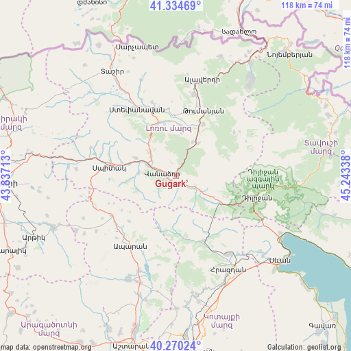
Gugark’ GPS coordinates[2]
40° 48' 16.56" North, 44° 32' 24.9" East
| Map corner | latitude | longitude |
|---|---|---|
| Upper-left | 41.33469°, | 43.83713° |
| Center: | 40.8046°, | 44.54025° |
| Lower-right: | 40.27024°, | 45.24338° |
| Map W x H: | 118.4×118.4 km | = 73.6×73.6mi |
| max Lat: | 41.24358° ⇑14.6% North |
| Gugark’: | 40.8046° |
| min Lat: | ⇓85.4% South 38.90292° |
| min Long | Gugark’ | max Long |
| 43.74722° | 44.54025° | 46.5446° |
| W 50.3%⇐ | ⇒49.7% E |
Elevation
Elevation of Gugark’ is 1320 m = 4331 ft, and this is 18.5 m = 61 ft above average elevation for this country.
| Max E: |
2169 m = 7116 ft | 48.4% |
| Gugark’ | 1320 m 4331 ft | |
| Avg. | 1301.5 m = 4270 ft | |
Min E: |
440 m = 1444 ft | 51.6% |
See also: Armenia elevation on elevation.city.
Geographical zone
Gugark’ is located in North temperate zone (between Tropic of Cancer and the Arctic Circle). Distance of this Northern Tropic circle is 1931.1 km =1199.9 mi to South.| Distance of | km | miles | from Gugark’ |
|---|---|---|---|
| North Pole | 5470 | 3398.9 | to North |
| Arctic Circle | 2864.1 | 1779.7 | to North |
| Tropic Cancer | 1931.1 | 1199.9 | to South |
| Equator | 4537 | 2819.2 | to South |


Nearby cities:
15 places around Gugark’: (largest is in red/bold)
• Arevashogh
23.2 km =14.4 mi,  285°
285°
• Bazum
11 km =6.8 mi,  309°
309°
• Darpas
10.3 km =6.4 mi, 290°
• Dsegh
19.8 km =12.3 mi,  27°
27°
• Fioletovo
17.5 km =10.9 mi,  121°
121°
• Gyulagarak
19 km =11.8 mi,  342°
342°
• Lerrnants’k’
22.4 km =13.9 mi,  267°
267°
• Lerrnapat
12.4 km =7.7 mi,  275°
275°
• Margahovit
14.5 km =9 mi, 122°
• Shahumyan
3.3 km =2.1 mi,  171°
171°
• Spitak
23.2 km =14.4 mi, 277°
• Vahagni
12.8 km =8 mi, 26°
• Vanadzor
3.9 km =2.4 mi, 269°
• Vardablur
18.7 km =11.6 mi,  351°
351°
• Yeghegnut
13.4 km =8.3 mi,  35°
35°
Sources, notices
• [Note1] Compared only with cities in Armenia existing in our database
• [Src1] Map data: © OpenStreetMap contributors (CC-BY-SA)
• [Src2] Other city data from geonames.org with taken over terms of usage.
• [Src3] Geographical zone / Annual Mean Temperature by Robert A. Rohde @ Wikipedia
