Zovuni geodata
Zovuni (Aragatsotn) is a populated place; located in Armenia in Asia/Yerevan (GMT+4) time zone. With population of 4,484 people, there are 53 cities with bigger population in this country. Compared to other cities in Armenia, 68.8% of cities are located further ↓South; 57.6% of cities are located further →East and 84.4% of cities have lower elevation than Zovuni. Note1


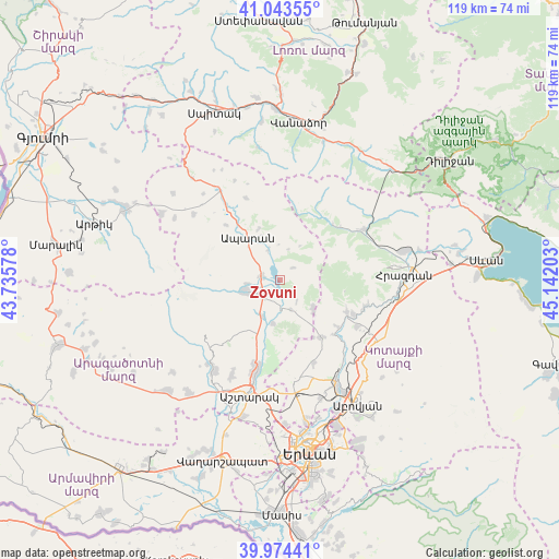
Zovuni GPS coordinates[2]
40° 30' 39.996" North, 44° 26' 20.04" East
| Map corner | latitude | longitude |
|---|---|---|
| Upper-left | 41.04355°, | 43.73578° |
| Center: | 40.51111°, | 44.4389° |
| Lower-right: | 39.97441°, | 45.14203° |
| Map W x H: | 118.9×118.9 km | = 73.9×73.9mi |
| max Lat: | 41.24358° ⇑31.2% North |
| Zovuni: | 40.51111° |
| min Lat: | ⇓68.8% South 38.90292° |
| min Long | Zovuni | max Long |
| 43.74722° | 44.4389° | 46.5446° |
| W 42.4%⇐ | ⇒57.6% E |
Elevation
Elevation of Zovuni is 1856 m = 6089 ft, and this is 554.5 m = 1819 ft above average elevation for this country.
| Max E: |
2169 m = 7116 ft | 15.6% |
| Zovuni | 1856 m 6089 ft | |
| Avg. | 1301.5 m = 4270 ft | |
Min E: |
440 m = 1444 ft | 84.4% |
See also: Armenia elevation on elevation.city.
Geographical zone
Zovuni is located in North temperate zone (between Tropic of Cancer and the Arctic Circle). Distance of this Northern Tropic circle is 1898.5 km =1179.7 mi to South.| Distance of | km | miles | from Zovuni |
|---|---|---|---|
| North Pole | 5502.6 | 3419.2 | to North |
| Arctic Circle | 2896.8 | 1800 | to North |
| Tropic Cancer | 1898.5 | 1179.7 | to South |
| Equator | 4504.4 | 2798.9 | to South |


Nearby cities:
15 places around Zovuni: (largest is in red/bold)
• Aparan
11.4 km =7.1 mi,  323°
323°
• Aragats
7.7 km =4.8 mi,  251°
251°
• Aragyugh
15 km =9.3 mi,  143°
143°
• Argel
20.1 km =12.5 mi, 137°
• Arzakan
15.9 km =9.9 mi,  115°
115°
• Bjni
18.8 km =11.7 mi,  108°
108°
• Buzhakan
9.2 km =5.7 mi,  132°
132°
• Karbi
20.7 km =12.9 mi,  194°
194°
• Kasakh
3.7 km =2.3 mi, 320°
• Meghradzor
20.8 km =12.9 mi,  59°
59°
• Shenavan
5.6 km =3.5 mi,  236°
236°
• Tsaghkahovit
22.8 km =14.2 mi,  306°
306°
• Ushi
19 km =11.8 mi,  196°
196°
• Yeghvard
21.1 km =13.1 mi,  169°
169°
• Zoravan
18.7 km =11.6 mi,  157°
157°
Sources, notices
• [Note1] Compared only with cities in Armenia existing in our database
• [Src1] Map data: © OpenStreetMap contributors (CC-BY-SA)
• [Src2] Other city data from geonames.org with taken over terms of usage.
• [Src3] Geographical zone / Annual Mean Temperature by Robert A. Rohde @ Wikipedia
