Lumeje geodata
Lumeje (Moxico) is a populated place; located in Angola in Africa/Luanda (GMT+1) time zone. With population of 4,972 people, there are 34 cities with bigger population in this country. Compared to other cities in Angola, 52.8% of cities are located further ↓South; 97.2% of cities are located further ←West and 50% of cities have lower elevation than Lumeje. Note1


Lumeje GPS coordinates[2]
11° 33' 0" South, 20° 46' 59.988" East
| Map corner | latitude | longitude |
|---|---|---|
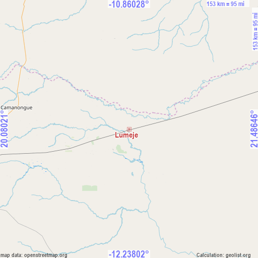
| Upper-left | -10.86028°, | 20.08021° |
| Center: | -11.55°, | 20.78333° |
| Lower-right: | -12.23802°, | 21.48646° |
| Map W x H: | 153.2×153.2 km | = 95.2×95.2mi |
| max Lat: | -5.55° ⇑47.2% North |
| Lumeje: | -11.55° |
| min Lat: | ⇓52.8% South -17.06667° |
| min Long | Lumeje | max Long |
| 12.15222° | 20.78333° | 22.22466° |
| W 97.2%⇐ | ⇒2.8% E |
Elevation
Elevation of Lumeje is 1144 m = 3753 ft, and this is 175.1 m = 574 ft above average elevation for this country.
| Max E: |
1895 m = 6217 ft | 50% |
| Lumeje | 1144 m 3753 ft | |
| Avg. | 968.9 m = 3179 ft | |
Min E: |
1 m = 3 ft | 50% |
See also: Angola elevation on elevation.city.
Geographical zone
Lumeje is located in South Torrid zone (between Equator and Tropic of Capricorn). Distance of Equator is 1284.2 km =798 mi to North.| Distance of | km | miles | from Lumeje |
|---|---|---|---|
| Equator | 1284.2 | 798 | to North |
| Tropic Capricorn | 1321.7 | 821.3 | to South |
| Antarctic Circle | 6116.9 | 3800.9 | to South |
| South Pole | 8722.8 | 5420.1 | to South |


Nearby cities:
10 places around Lumeje: (largest is in red/bold)
• Camacupa
362.9 km =225.5 mi,  261°
261°
• Catabola
386.7 km =240.3 mi, 260°
• Cazaji
54.4 km =33.8 mi,  350°
350°
• Chissamba
381.6 km =237.1 mi, 259°
• Cuito
428.9 km =266.5 mi, 257°
• Luau
183 km =113.7 mi,  59°
59°
• Lucapa
348.1 km =216.3 mi,  359°
359°
• Luena
97.9 km =60.8 mi,  254°
254°
• Léua
38 km =23.6 mi, 252°
• Saurimo
214.4 km =133.2 mi, 348°
Sources, notices
• [Note1] Compared only with cities in Angola existing in our database
• [Src1] Map data: © OpenStreetMap contributors (CC-BY-SA)
• [Src2] Other city data from geonames.org with taken over terms of usage.
• [Src3] Geographical zone / Annual Mean Temperature by Robert A. Rohde @ Wikipedia
