Camacupa geodata
Camacupa (Bíe) is a populated place; located in Angola in Africa/Luanda (GMT+1) time zone. With population of 19,150 people, there are 21 cities with bigger population in this country. Compared to other cities in Angola, 55.6% of cities are located further ↑North; 77.8% of cities are located further ←West and 77.8% of cities have lower elevation than Camacupa. Note1


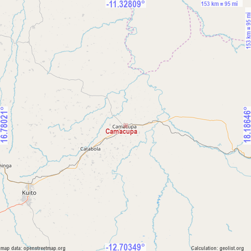
Camacupa GPS coordinates[2]
12° 1' 0.012" South, 17° 28' 59.988" East
| Map corner | latitude | longitude |
|---|---|---|
| Upper-left | -11.32809°, | 16.78021° |
| Center: | -12.01667°, | 17.48333° |
| Lower-right: | -12.70349°, | 18.18646° |
| Map W x H: | 152.9×152.9 km | = 95×95mi |
| max Lat: | -5.55° ⇑55.6% North |
| Camacupa: | -12.01667° |
| min Lat: | ⇓44.4% South -17.06667° |
| min Long | Camacupa | max Long |
| 12.15222° | 17.48333° | 22.22466° |
| W 77.8%⇐ | ⇒22.2% E |
Elevation
Elevation of Camacupa is 1473 m = 4833 ft, and this is 504.1 m = 1654 ft above average elevation for this country.
| Max E: |
1895 m = 6217 ft | 22.2% |
| Camacupa | 1473 m 4833 ft | |
| Avg. | 968.9 m = 3179 ft | |
Min E: |
1 m = 3 ft | 77.8% |
See also: Angola elevation on elevation.city.
Geographical zone
Camacupa is located in South Torrid zone (between Equator and Tropic of Capricorn). Distance of this Southern Tropic circle is 1269.8 km =789 mi to South.| Distance of | km | miles | from Camacupa |
|---|---|---|---|
| Equator | 1336.1 | 830.2 | to North |
| Tropic Capricorn | 1269.8 | 789 | to South |
| Antarctic Circle | 6065 | 3768.6 | to South |
| South Pole | 8670.9 | 5387.8 | to South |


Nearby cities:
15 places around Camacupa: (largest is in red/bold)
• Caconda
324.1 km =201.4 mi,  233°
233°
• Catabola
26.3 km =16.3 mi,  235°
235°
• Caála
228.5 km =142 mi,  246°
246°
• Chela
225.1 km =139.9 mi,  261°
261°
• Chinjenje
289 km =179.6 mi, 249°
• Chissamba
23.3 km =14.5 mi,  224°
224°
• Cuito
72.4 km =45 mi, 235°
• Huambo
207.4 km =128.9 mi, 245°
• Longonjo
261.6 km =162.6 mi, 247°
• Luena
266 km =165.3 mi,  84°
84°
• Léua
325.4 km =202.2 mi, 82°
• Malanje
302.3 km =187.8 mi,  335°
335°
• Menongue
294.6 km =183.1 mi,  175°
175°
• Quibala
307.9 km =191.3 mi,  297°
297°
• Uacu Cungo
267.9 km =166.5 mi,  285°
285°
Sources, notices
• [Note1] Compared only with cities in Angola existing in our database
• [Src1] Map data: © OpenStreetMap contributors (CC-BY-SA)
• [Src2] Other city data from geonames.org with taken over terms of usage.
• [Src3] Geographical zone / Annual Mean Temperature by Robert A. Rohde @ Wikipedia
