Léua geodata
Léua (Moxico) is a populated place; located in Angola in Africa/Luanda (GMT+1) time zone. With population of 5,168 people, there are 33 cities with bigger population in this country. Compared to other cities in Angola, 50% of cities are located further ↓South; 88.9% of cities are located further ←West and 55.6% of cities have lower elevation than Léua. Note1


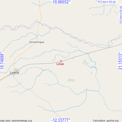
Léua GPS coordinates[2]
11° 39' 0" South, 20° 27' 0" East
| Map corner | latitude | longitude |
|---|---|---|
| Upper-left | -10.96052°, | 19.74688° |
| Center: | -11.65°, | 20.45° |
| Lower-right: | -12.33777°, | 21.15313° |
| Map W x H: | 153.1×153.1 km | = 95.1×95.1mi |
| max Lat: | -5.55° ⇑50% North |
| Léua: | -11.65° |
| min Lat: | ⇓50% South -17.06667° |
| min Long | Léua | max Long |
| 12.15222° | 20.45° | 22.22466° |
| W 88.9%⇐ | ⇒11.1% E |
Elevation
Elevation of Léua is 1236 m = 4055 ft, and this is 267.1 m = 876 ft above average elevation for this country.
| Max E: |
1895 m = 6217 ft | 44.4% |
| Léua | 1236 m 4055 ft | |
| Avg. | 968.9 m = 3179 ft | |
Min E: |
1 m = 3 ft | 55.6% |
See also: Angola elevation on elevation.city.
Geographical zone
Léua is located in South Torrid zone (between Equator and Tropic of Capricorn). Distance of Equator is 1295.4 km =804.9 mi to North.| Distance of | km | miles | from Léua |
|---|---|---|---|
| Equator | 1295.4 | 804.9 | to North |
| Tropic Capricorn | 1310.6 | 814.4 | to South |
| Antarctic Circle | 6105.8 | 3794 | to South |
| South Pole | 8711.7 | 5413.2 | to South |


Nearby cities:
10 places around Léua: (largest is in red/bold)
• Camacupa
325.4 km =202.2 mi,  262°
262°
• Catabola
349 km =216.9 mi, 260°
• Cazaji
70.4 km =43.7 mi,  22°
22°
• Chissamba
343.9 km =213.7 mi, 260°
• Cuito
391 km =243 mi, 257°
• Luau
220.1 km =136.8 mi,  61°
61°
• Lucapa
360.7 km =224.1 mi,  5°
5°
• Luena
59.9 km =37.2 mi, 255°
• Lumeje
38 km =23.6 mi,  72°
72°
• Saurimo
221.3 km =137.5 mi,  358°
358°
Sources, notices
• [Note1] Compared only with cities in Angola existing in our database
• [Src1] Map data: © OpenStreetMap contributors (CC-BY-SA)
• [Src2] Other city data from geonames.org with taken over terms of usage.
• [Src3] Geographical zone / Annual Mean Temperature by Robert A. Rohde @ Wikipedia
