Catabola geodata
Catabola (Bíe) is a populated place; located in Angola in Africa/Luanda (GMT+1) time zone. With population of 18,855 people, there are 22 cities with bigger population in this country. Compared to other cities in Angola, 58.3% of cities are located further ↑North; 72.2% of cities are located further ←West and 80.6% of cities have lower elevation than Catabola. Note1


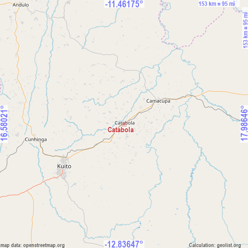
Catabola GPS coordinates[2]
12° 9' 0" South, 17° 16' 59.988" East
| Map corner | latitude | longitude |
|---|---|---|
| Upper-left | -11.46175°, | 16.58021° |
| Center: | -12.15°, | 17.28333° |
| Lower-right: | -12.83647°, | 17.98646° |
| Map W x H: | 152.9×152.9 km | = 95×95mi |
| max Lat: | -5.55° ⇑58.3% North |
| Catabola: | -12.15° |
| min Lat: | ⇓41.7% South -17.06667° |
| min Long | Catabola | max Long |
| 12.15222° | 17.28333° | 22.22466° |
| W 72.2%⇐ | ⇒27.8% E |
Elevation
Elevation of Catabola is 1531 m = 5023 ft, and this is 562.1 m = 1844 ft above average elevation for this country.
| Max E: |
1895 m = 6217 ft | 19.4% |
| Catabola | 1531 m 5023 ft | |
| Avg. | 968.9 m = 3179 ft | |
Min E: |
1 m = 3 ft | 80.6% |
See also: Angola elevation on elevation.city.
Geographical zone
Catabola is located in South Torrid zone (between Equator and Tropic of Capricorn). Distance of this Southern Tropic circle is 1255 km =779.8 mi to South.| Distance of | km | miles | from Catabola |
|---|---|---|---|
| Equator | 1351 | 839.5 | to North |
| Tropic Capricorn | 1255 | 779.8 | to South |
| Antarctic Circle | 6050.2 | 3759.4 | to South |
| South Pole | 8656.1 | 5378.6 | to South |


Nearby cities:
15 places around Catabola: (largest is in red/bold)
• Caconda
297.8 km =185 mi,  233°
233°
• Camacupa
26.3 km =16.3 mi,  55°
55°
• Caála
202.7 km =126 mi,  247°
247°
• Chela
201.7 km =125.3 mi,  265°
265°
• Chinjenje
263.4 km =163.7 mi, 250°
• Chissamba
5.7 km =3.5 mi,  108°
108°
• Cuito
46 km =28.6 mi,  235°
235°
• Huambo
181.5 km =112.8 mi, 247°
• Longonjo
235.9 km =146.6 mi, 249°
• Luena
289.3 km =179.8 mi,  81°
81°
• Léua
349 km =216.9 mi, 80°
• Malanje
307.9 km =191.3 mi,  340°
340°
• Menongue
282.4 km =175.5 mi,  171°
171°
• Quibala
296.3 km =184.1 mi,  302°
302°
• Uacu Cungo
251.8 km =156.5 mi,  290°
290°
Sources, notices
• [Note1] Compared only with cities in Angola existing in our database
• [Src1] Map data: © OpenStreetMap contributors (CC-BY-SA)
• [Src2] Other city data from geonames.org with taken over terms of usage.
• [Src3] Geographical zone / Annual Mean Temperature by Robert A. Rohde @ Wikipedia
