Luena geodata
Luena (Moxico) is a seat of a first-order administrative division; located in Angola in Africa/Luanda (GMT+1) time zone. With population of 21,115 people, there are 19 cities with bigger population in this country. Compared to other cities in Angola, 52.8% of cities are located further ↑North; 83.3% of cities are located further ←West and 66.7% of cities have lower elevation than Luena. Note1


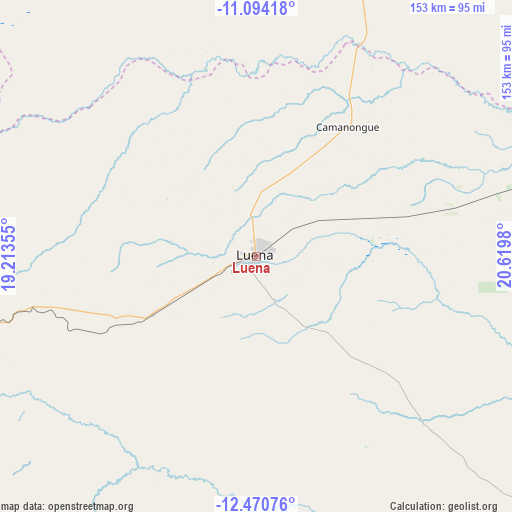
Luena GPS coordinates[2]
11° 46' 59.988" South, 19° 55' 0.012" East
| Map corner | latitude | longitude |
|---|---|---|
| Upper-left | -11.09418°, | 19.21355° |
| Center: | -11.78333°, | 19.91667° |
| Lower-right: | -12.47076°, | 20.6198° |
| Map W x H: | 153.1×153.1 km | = 95.1×95.1mi |
| max Lat: | -5.55° ⇑52.8% North |
| Luena: | -11.78333° |
| min Lat: | ⇓47.2% South -17.06667° |
| min Long | Luena | max Long |
| 12.15222° | 19.91667° | 22.22466° |
| W 83.3%⇐ | ⇒16.7% E |
Elevation
Elevation of Luena is 1337 m = 4386 ft, and this is 368.1 m = 1208 ft above average elevation for this country.
| Max E: |
1895 m = 6217 ft | 33.3% |
| Luena | 1337 m 4386 ft | |
| Avg. | 968.9 m = 3179 ft | |
Min E: |
1 m = 3 ft | 66.7% |
See also: Angola elevation on elevation.city.
Geographical zone
Luena is located in South Torrid zone (between Equator and Tropic of Capricorn). Distance of this Southern Tropic circle is 1295.7 km =805.1 mi to South.| Distance of | km | miles | from Luena |
|---|---|---|---|
| Equator | 1310.2 | 814.1 | to North |
| Tropic Capricorn | 1295.7 | 805.1 | to South |
| Antarctic Circle | 6091 | 3784.8 | to South |
| South Pole | 8696.9 | 5404 | to South |


Nearby cities:
11 places around Luena: (largest is in red/bold)
• Camacupa
266 km =165.3 mi,  264°
264°
• Catabola
289.3 km =179.8 mi, 261°
• Cazaji
116.9 km =72.6 mi,  47°
47°
• Chissamba
284.2 km =176.6 mi, 261°
• Cuito
331.2 km =205.8 mi, 258°
• Luau
278.7 km =173.2 mi,  64°
64°
• Lucapa
384.9 km =239.2 mi,  13°
13°
• Lumeje
97.9 km =60.8 mi,  74°
74°
• Léua
59.9 km =37.2 mi,  75°
75°
• Menongue
400.3 km =248.7 mi,  216°
216°
• Saurimo
241.6 km =150.1 mi, 12°
Sources, notices
• [Note1] Compared only with cities in Angola existing in our database
• [Src1] Map data: © OpenStreetMap contributors (CC-BY-SA)
• [Src2] Other city data from geonames.org with taken over terms of usage.
• [Src3] Geographical zone / Annual Mean Temperature by Robert A. Rohde @ Wikipedia
