Maciá geodata
Maciá (Entre Rios) is a populated place; located in Argentina in America/Argentina/Cordoba (GMT-3) time zone. With population of 5,806 people, there are 406 cities with bigger population in this country. Compared to other cities in Argentina, 53.1% of cities are located further ↑North; 72.5% of cities are located further ←West and 71.7% of cities have higher elevation than Maciá. Note1


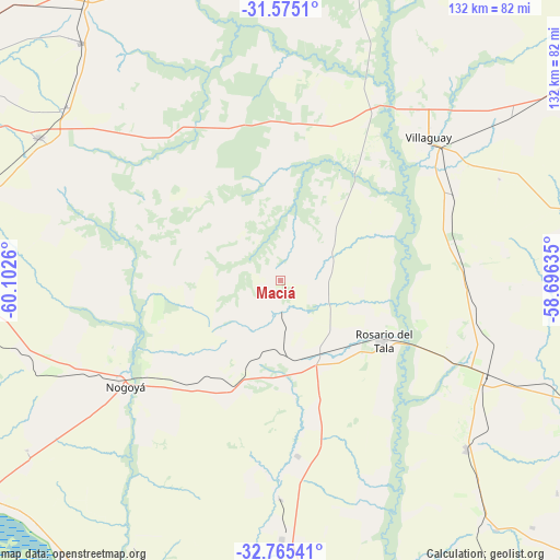
Maciá GPS coordinates[2]
32° 10' 19.92" South, 59° 23' 58.092" West
| Map corner | latitude | longitude |
|---|---|---|
| Upper-left | -31.5751°, | -60.1026° |
| Center: | -32.1722°, | -59.39947° |
| Lower-right: | -32.76541°, | -58.69635° |
| Map W x H: | 132.4×132.4 km | = 82.3×82.3mi |
| max Lat: | -21.94467° ⇑53.1% North |
| Maciá: | -32.1722° |
| min Lat: | ⇓46.9% South -54.81084° |
| min Long | Maciá | max Long |
| -72.88605° | -59.39947° | -53.64581° |
| W 72.5%⇐ | ⇒27.5% E |
Elevation
Elevation of Maciá is 76 m = 249 ft, and this is 273.3 m = 897 ft below average elevation for this country.
| Max E: |
4040 m = 13255 ft | 71.7% |
| Avg. | 349.3 m = 1146 ft | |
| Maciá | 76 m = 249 ft | |
Min E: |
-2 m = -7 ft | 28.3% |
See also: Argentina elevation on elevation.city.
Geographical zone
Maciá is located in South temperate zone (between Tropic of Capricorn and the Antarctic Circle). Distance of this Southern Tropic circle is 971.3 km =603.5 mi to North.| Distance of | km | miles | from Maciá |
|---|---|---|---|
| Equator | 3577.2 | 2222.8 | to North |
| Tropic Capricorn | 971.3 | 603.5 | to North |
| Antarctic Circle | 3824 | 2376.1 | to South |
| South Pole | 6429.8 | 3995.3 | to South |


Nearby cities:
15 places around Maciá: (largest is in red/bold)
• Aranguren
72.1 km =44.8 mi,  263°
263°
• Domínguez
46.1 km =28.6 mi,  63°
63°
• General Galarza
60.9 km =37.8 mi,  179°
179°
• Gilbert
59.7 km =37.1 mi,  132°
132°
• Gobernador Mansilla
41.6 km =25.8 mi,  174°
174°
• Hernández
61.3 km =38.1 mi,  252°
252°
• Lucas González
26.6 km =16.5 mi,  207°
207°
• Nogoyá
44.2 km =27.5 mi,  236°
236°
• Rosario del Tala
28 km =17.4 mi,  121°
121°
• Santa Anita
57.7 km =35.9 mi,  90°
90°
• Seguí
72.4 km =45 mi,  289°
289°
• Tabossi
65.2 km =40.5 mi,  309°
309°
• Viale
66.5 km =41.3 mi,  300°
300°
• Villa Mantero
66.3 km =41.2 mi,  112°
112°
• Villaguay
49 km =30.4 mi,  45°
45°
Sources, notices
• [Note1] Compared only with cities in Argentina existing in our database
• [Src1] Map data: © OpenStreetMap contributors (CC-BY-SA)
• [Src2] Other city data from geonames.org with taken over terms of usage.
• [Src3] Geographical zone / Annual Mean Temperature by Robert A. Rohde @ Wikipedia
